D. Slejko (1), R. Camassi (2), I. Cecic (3), D. Herak (4), M. Herak (4), S. Kociu (5), V. Kouskouna (6), J. Lapajne (3), K. Makropoulos (6), C. Meletti (7), B. Muco (5), C. Papaioannou (8), L. Peruzza (9), A. Rebez (1), P. Scandone (10), E. Sulstarova (5), N. Voulgaris (6), M. Zivcic (3) and P. Zupancic (3)
(1) Osservatorio Geofisico Sperimentale, Trieste, Italy
(2) Gruppo Nazionale Difesa Terremoti c/o Univ., Bologna, Italy
(3) Geophysical Survey of Slovenia, Ljubljana, Slovenia
(4) Geophysical Institute, University, Zagreb, Croatia
(5) Seismological Institute, Tirana, Albania
(6) Dept. Geophysics, University, Athens, Greece
(7) Gruppo Nazionale Difesa Terremoti c/o Univ. Pisa, Italy
(8) Inst. Eng. Seismology and Earth. Engineering, Thessaloniki, Greece
(9) Gruppo Nazionale Difesa Terremoti c/o Oss. Geof. Sperim., Trieste,
Italy
(10) Dip. Scienze della Terra, Univ. Pisa, Italy
1. Introduction
In the framework of the Global Seismic Hazard Assessment Program (GSHAP, see Giardini and Basham, 1993), there are three test areas which refer to continental Europe and the Mediterranean: the Germany, Austria, and Switzerland (DACH) region, the Ibero - Magrebian region, and the Adriatic region (Adria), which is, therefore, a kind of link between the DACH and the Ibero - Magrebian regions (see the Adria project in Slejko, 1994).
The choice of Adria (limited by the Apennines to the west, the Alps to the north, the Dinarides-Hellenides as far as the Cephalonia escarpment to the east, and the Ionian abyssal plain to the south) as test area is motivated by several reasons: a) the problem of the geodynamic evolution of the Adriatic microplate is still open and is of fundamental importance for the geophysical knowledge of the Mediterranean region; b) the seismicity of the peri-Adriatic region is poorly known because up to now it has been investigated only at a national scale, while the analysis should be done on international bases; c) several countries with noteworthy scientific experience face the Adriatic Sea; d) relations between the seismicity at the western and the eastern margins of the Adriatic microplate can be postulated; and e) only for the eastern part of the area (Balkans) has an international project for seismic hazard assessment been performed, while the border problems in the remaining part have never been considered.
Moreover, the probabilistic hazard assessment of Adria benefits from two favourable factors: a) the compilation of an European catalogue, prepared in the frame of the EC project "A Basic European Earthquake Catalogue and Database" (BEECD; Stucchi, 1998); b) the possibility of applying the kinematic model of the seismogenic zonation of Italy (Scandone et al., 1992; Meletti et al., 1998) to whole Adria.
For some of the regions considered in the project, different hazard
estimates were performed in the past. More precisely, UNESCO's Balkan Project
computed hazard estimates for the whole eastern Adriatic region, from former
Yugoslavia to Greece (Algermissen et al., 1976). In the following years
the hazard assessment of Greece was updated several times (e. g.: Makropoulos
and Burton, 1985). Recently, probabilistic hazard maps were presented for
Slovenia (Lapajne et al., 1997). Furthermore, the long lasting project
for the seismic hazard assessment of Italy for the revision of the national
seismic zonation has recently ended (Slejko et al., 1998b).
1.1. The Adria project
The first meeting of the Adria project was held in Trieste, on June 27-28, 1994. Representatives of the countries facing the Adriatic sea and other experts convened to establish the methodology and the general guidelines for the seismic hazard assessment. In particular, the seismic hazard of whole Adria has been regarded as the natural continuation of the Italian experience in the framework of CNR's National Group for the Defence against Earthquakes (GNDT). The second meeting was held in Athens, on September 21, 1995. A first seismotectonic model was discussed, and some modifications to the boundaries of the sources were introduced by the seismicity data analyses, with the general agreement of all the partners. A third meeting was held in Thessaloniki, during the 1997 assembly of the International Association of Seismology and Physics of the Earth's Interior (IASPEI), to comment on some preliminary hazard estimates. The fourth and final meeting was held in Pisa on February 5 - 6, 1998 for the final shaping of some coastal Balkan SZ's, on the basis of the general kinematic model of the region, after having considered in detail the hazard results.
The input data for the hazard assessment of Adria were presented during the 1996 congress of the Carpatho - Balkan Geological Association, in Athens (Slejko, 1996). The preliminary results of the Adria project were presented at the GSHAP meeting during the IASPEI conference held in Thessaloniki in 1997 (Peruzza et al., 1997); these are the global definition of the earthquake source-zones all around the Adriatic Sea and the map of the horizontal peak ground acceleration (PGA) with a 475 year return period (corresponding to 10% exceedance probability in 50 years). Further elaborations were presented in 1998 during the general assembly of the European Geophysical Society held in Nice (Slejko et al., 1998a).
The final hazard results were shown during the general assembly of the
European Seismological Commission held in Tel Aviv, and at the European
Conference on Earthquake Engineering held in Paris (Peruzza et al., 1998),
both in 1998.
2. Seismotectonic modelling and seismogenic zoning
The area under study belongs to the complex structural environment of
the central Mediterranean region. Here African and Eurasian plates collide,
giving origin to some seismically active belts.
2.1. Kinematics of the ADRIA region
The basic product for delineating seismogenic sources is an adequate kinematic model, capable of explaining the recent (Late Tertiary - Quaternary) evolution of the whole area and describing the actual movements linked to the seismicity. The seismotectonics of Adria was approached by extending the seismotectonic analysis of the Italian territory, performed in the frame of the GNDT activities (Scandone et al., 1992; Meletti et al., 1998).
The Padan-Adriatic region (see Fig. 1) is currently interpreted as a rigid microplate bordered, on the eastern, northern and western margins, by a mobile mountain belt which includes the Albanides, the Dinarides, the Alps and the Apennines. The southern margin of the plate, that is the Africa-Adria boundary, is still undefined although geological and geodetical evidence points to a significant divergence between southern Sicily and Apulia. We suggest a possible southward extension of Adria as far as the Malta escarpment where active extensional faults cutting across the entire crust have been recognized and where high-energy destructive earthquakes have been recorded in historical times.
The reconstruction of the Neogene-Quaternary relative motion of Adria versus Europe is well constrained by the geometrical configuration of the Insubric indenter in the Western Alps, as well as by the geometry of the young thrust systems in the Southern Alps, Dinarides and Albanides. A rotation pole located in western Liguria (RP in Fig. 1) may simultaneously justify the major structural features of the region as well as the geodetic results (black full arrows in Fig. 1) in the Matera site which show a SW-NE slip vector diverging considerably from the SE-NW slip vector of the Noto site (Ward, 1994). The relative motion of Adria around the above mentioned pole obviously requires kinematic agreement between active tectonic structures and calculated slip vectors. Most of the focal mechanisms available in the Dinarides-Hellenides (Fig. 2) actually agree with the kinematic model showing P-axes consistent with the regional slip vectors and fault planes represented by pure contractional faults or by dextral transpressive faults. Transversal features which interrupt the longitudinal belts are interpreted as lateral ramps and they accommodate different geometries in the active thrust trajectories. A significant transversal fault zone has been recognized in correspondence to the boundary between the Dinarides and the Albanides. This tectonic accident, which separates the western undeformed part of the southern Adriatic basin from the eastern deformed part and links active segments of thrust fronts, is well documented by reflection seismic lines. The most evident transversal fault is represented by the Cephalonia escarpment which has been interpreted as a first-order lateral ramp of the thrust belt, developed in correspondence to the western margin of the Hellenic Arc.
Due to the relative motion of Adria, no plate convergence can explain the recent tectonic evolution of the Apennines which appears to have been entirely controlled by passive subduction processes, characterized by high-rate flexure-hinge retreat in the lower plate and by back-arc opening in the upper plate. Slab sinking is still an active process in the northern Apenninic Arc, where a mobile axial belt characterized by strong shallow earthquakes has been recognized, and is bordered by compressional and extensional active belts, respectively along the Adriatic and the Tyrrhenian margins of the mountain chain. In the southern Apennines, on the contrary, passive subduction processes and consequent arc migration ended around 0.65 Ma; due to the persisting Adria-Europe convergence, extensional processes have developed since then, with a generation of young normal faults superimposed on the inactive contractional structures.
The seismogenic zones (SZ's) in the peri-Adriatic region, that will
be shaped according to seismicity data too, represent the surface projection
of active fault systems capable of producing earthquakes characterized
by consistent kinematic behaviour. Future research should be addressed
to recognize and characterize single active structures, to distinguish
the big earthquakes related to finite segments of major faults from the
small ones, assumed to be minor breakages, randomly distributed within
polygons encompassing low-potential seismic sources.
3. Seismicity and earthquake catalogues of the Adria region
The region studied interests different countries and a global, multi-national analysis of its seismicity has never been produced.
Seismicity has been studied mainly by the individual countries, for
the development of national earthquake catalogues. Only a few examples
of analysis on the correlation between the seismicity at the eastern and
western Adria margins can be found in literature (e.g. Mantovani et al.,
1987).
3.1. Seismicity distribution
Sea waters cover a large part of the study area, hence the seismicity pattern is poorly controlled: historical data collected along the coasts can be biased if the actual sources are offshore (Albini et al., 1994). Similarly instrumental seismicity is poorly located by the few and often badly spaced recording stations. Mislocations are, therefore, frequent, generally resulting in a not perfect agreement among the epicentral coordinates in parametric catalogues for earthquakes which occurred in the Adriatic Sea. Relocations of recent events in the sea, considering all the available data (e. g.: Console et al., 1993; Favali et al., 1993; Renner and Slejko, 1994), has shown that the improvement obtained is notable only in some cases and this emphasizes the importance of a good data collection for studying the seismogenesis of marine seismic sources. All this considered, however, the seismicity in the Adriatic Sea appears to be really low (Fig. 3), with intraplate characteristics, and no seismically active southward margin between the Adria and the African plate can be recognised, leaving the problem of the Adria geometry still open.
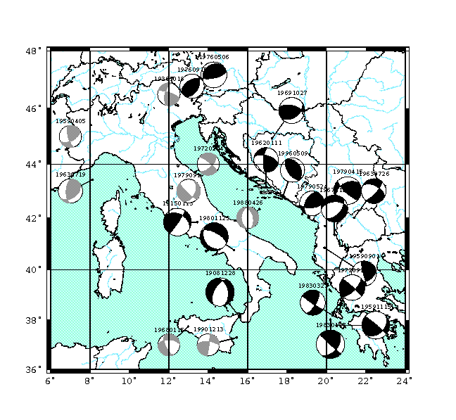
On the other boundaries, Adria is surrounded by earthquakes along all the Balkan coasts, the southern Alps, and the Apennines (Anderson and Jackson, 1987). A simplified sketch of the recent, major earthquakes of this century is given in Fig. 2. Interplate margin seismicity in the Apennines expresses both compressional and extensional earthquakes (Pantosti et al., 1993; Frepoli and Amato, 1997), and strike-slip mechanisms are located where the lateral continuity of the arcs is broken. The Po plain mimics a sort of gap in the seismicity distribution; strike-slip and reverse fault mechanisms become prevalent on the borders of the Adria indentation in the Western Alps (e. g. Eva et al., 1997). The southern Alps are mainly characterized by thrust mechanisms, and the maximum compression is expected to be N-S oriented in the Friuli region (e. g. Bressan et al., 1997), with a gradual transition to transcurrent characteristics both westwards (e. g. the 1936 Belluno earthquake, Peruzza et al., 1989) and eastwards (e. g. the 1997 Bovec earthquake, associated to the Idrija line, Bragato et al., 1998). A decrease in the activity is located in northern Dalmatia, where the seismicity vanishes. Again along the Dinarides, from Slovenia to the island of Cephalonia thrust and strike-slip mechanisms have been observed mainly (Console and Favali, 1991).
Seismicity is typical of subduction zones in the Aegean and the Calabrian
Arc; in the latter case the flexural retreat is expected to cease, and
the actual rebound regime suggests dip slip mechanisms in the upper plate,
and compressional deep events along the slab (e.g. Neri et al., 1996).
3.2. Characteristics of the catalogue
The earthquake catalogue used for the hazard assessment of Adria is constituted by two main parts: the Italian catalogue and the catalogue of the Adriatic Balkan countries (Slovenia, Croatia, Yugoslavia, Albania, and Greece).
For the Italian area, the data used come from the GNDT catalogue NT4.1 (Camassi and Stucchi, 1996),expressly designed for hazard purposes. This catalogue is completely new characterized, for example, by the fact that it contains main events only. At present, the NT4.1 catalogue contains 2421 records of earthquakes in the time window 1000-1980, with epicentral intensity Io larger than, or equal to, V-VI Mercalli - Cancani - Sieberg (MCS, see e. g.: Console and Gasparini, 1977), or magnitude Ms larger than, or equal to, 4.0. This catalogue lists earthquakes (main events only) whose epicenters are included in a polygon comprising all the SZ's of interest for hazard assessment in Italy. The catalogue is updated and freely available for scientific purposes at the official GNDT web site http://emidius.itim.mi.cnr.it/NT.html. The site also contains a description of the catalogue, format, compiling modalities, characteristics, bibliography and suggestions for users.
The catalogue for the eastern coast of the Adriatic Sea has been expressly assembled for this project. The events which occurred in this area before 1900 have been taken from the pre-release (Stucchi, 1998) of the European earthquake catalogue, developed in the frame of the EC research project BEECD. The last century events have been gathered from the sameparametric input catalogues selected by the BEECD project; a short description follows.
For Slovenia, the printed version of the catalogue by Ribaric (1982), recompiled according the BEECD criteria, has been adopted; the catalogue covers the Slovenian territory almost exclusively and most records derive from seismological compilations and bulletins. It contains 2758 earthquakes in the time window 792-1981.
For Croatia, the parametric catalogue provided by Herak (1995) for the BEECD was adopted together with its revised version (Herak et al., 1996) and submitted for the GSHAP project. This catalogue covers a very large area (it contains also many events far from Croatia) and seems to be a re-compilation of different national catalogues and previous parametric compilations, together with some corrections and expert judgements. The catalogue also reports many original instrumental locations (Herak et al., 1996) performed for Croatia and its surroundings, and contains 12333 events in the time window 373 BC - 1996.
For Albania, an updated version of the catalogue by Sulstarova and Kociu (1975), provided for the GSHAP project, has been adopted; for the 20th century it is mostly based on instrumental determinations.
For Greece, two different parametric catalogues are available: one is instrumental (Makropoulos and Burton, 1981), containing more than 5500 records for the 20th century only, the other (Papazachos and Papazachou, 1989) is derived from macroseismic investigations which represent the historical part only.
Two additional parametric catalogues are available for the whole area: the first (Shebalin et al , 1974), covers the Balkan area and is a compilation, in a same homogeneous format, of different national files; despite the fact that it is dated, it seems useful for its general homogeneity; the second additional file is by Legros and Bonnin (1996) containing more than 30000 instrumental data, but seems really useful only with respect to the last decades.
This post-1900 part of the Adria catalogue has been prepared following the main guidelines of the BEECD project, with the difference that in this time period a lot of instrumental data must be treated while the data of the BEECD catalogue come from macroseismic historical information. During the preparation of the catalogue of this century, the choice of the preferred record in the presence of multiple determinations (coming from different parametric catalogues), followed these steps:
a) cross-references of records among catalogues were identified and marked: the clones of original records were excluded, as they can be affected by errors;
b) multiple determinations were compared and selected according to the following rules: a) records reporting the roots (i. e.: the linking to the original data) were preferred; b) in the presence of more records with roots, the one with the most reliable roots was selected; c) in the presence of more records based on the same roots, the eldest was preferred as the younger ones could have been its clones.
In addition, a kind of indirect territorial competence was assigned to some input catalogues (e. g.: Ribaric, 1982 for Slovenia, and Makropoulos and Burton, 1981 for Greece). High priority was given to Shebalin et al. (1974), that catalogue was for some regions constructed on a better dataset with respect to the other input catalogues.
The concept of magnitude for the GNDT catalogue was designed for hazard purposes so, an homogeneous magnitude value was assigned to each event of the Italian catalogue. The reference magnitude is Ms and, when not directly available, has been derived from other types of magnitudes (Ml and Mb). For the historical period, it has been computed from macroseismic intensity using an ad hoc developed relation (Camassi and Stucchi, 1996). The same kind of approach has been adopted for the Balkan part of the catalogue using the same intensity-magnitude conversion developed for Italy, as that relation was calibrated using many Balkan earthquakes also. It should noticed that, while the Italian catalogue contains strictly controlled and revised data, the Balkan part has a lower level of accuracy, due to the complex management of many parametric catalogues which make up to the final catalogue, as well as to the fact that it is often very difficult to ascertain the type of magnitude reported in some catalogues.
In the traditional probabilistic seismic hazard assessment
(Cornell, 1968) chosen by GSHAP, independent events must be treated. The
Italian catalogue (Camassi and Stucchi, 1996) already satisfies this requirement
while the working file obtained for Adria by merging the basic catalogues
does not. Standard parameters (Gardner and Knopoff, 1974) were adopted
to declaster earthquakes in the study region.
4. Earthquake source zones
The seismogenic zonation is finally derived, according
to surface projections of active fault systems capable of earthquakes,
and seismicity patterns. In Fig. 4 and its legend, the kinematic behaviour
is emphasized. Then, in Fig. 5, the source geometry is overlaid to the
selected seismicity.
4.1. Description of the Adria sources
The SZ's properly defined for Adria are shortly commented
hereafter. A more detailed description is given in Meletti et al. (1998)
for Italy. The source numbers can be found in Fig. 4.
4.1.1 Greece
SZ 81 falls entirely in Greek territory and SZ 82
partly in Greece and partly in Albania. SZ 81 is a first order transfer
structure identified in the Cephalonia-Lefkas line: the source acts as
dextral transversal belt, a behaviour that is in full agreement with the
seismicity data. Some problems concern the prolongation inland of the source,
and the possible identification of two sub-segments. After long debate,
the final choice is to maintain one single source (see also Anzidei et
al., 1997; Louvari et al., 1997) but only for a limited part which extends
inland. The hypothesis of two SZ's (linked respectively to the Cephalonia
and Lefkas faults) has been discarded to avoid a too tight identification
of SZ with fault trace, and therefore a different approach with respect
to the one used for other sources. SZ 82 represents the compressive front
of southern Albania - southwestern Greece.
4.1.2 Albania
SZ's 83 and 84 pertain to Albania and SZ 82 partly
to Albania and partly to Greece. The compressional belt in Montenegro (SZ
85) is well defined, both by geological evidence and seismicity (focal
mechanisms systematically indicate reverse faults NW-SE oriented); similarly
in south Albania and the Corfu region (SZ 82) the compressional belt is
NW-SE oriented. The connection between these two areas characterized by
a compressional regime (the slip vector is orthogonal, defining, therefore,
nearly pure compression) has to be a dextral transfer zone. After careful
evaluation of the available material (Kociu, written communication; Muco,
1997; Sulstarova et al., 1997), SZ 83 was designed as a transfer zone that
acts as a dextral shear zone, where a maximum shear stress E-W oriented
is expected. This kinematic behaviour would be coherent with the available
focal mechanisms showing E-W oriented P axes and with a possible dextral
strike slip motion along NE-SW striking faults. The lateral width of the
shear zone must be 30 - 40, km adequate enough to contain structures capable
of an M = 6.0 earthquake; the western limit of the shear zone is blocked
by the southernmost earthquakes of the Montenegro region, and the eastern
one is consequently fixed. The seismicity of the inner northeastern sector
(Diber area, with extensional character, see Sulstarova et al., 1997) is
referred to a separate domain with NE - SW orientation: its kinematics
is probably not directly linked to Adria. We discarded the hypothesis that
it acts like a synthetic structure of the shear zone as the magnitudes
involved here are comparable (and not lower, as expected on synthetic faults)
with those of the shear zone itself, and the available mechanisms show
a dip-slip motion. For this reason the SZ 84 is not referred to a given
regime.
4.1.3 Bosnia and Yugoslavia
The compressional belt in this coastal area is split
into two parallel strips with different seismicity rates but similar kinematic
behaviour (SZ's 85 and 86); both geological evidence, and seismicity (focal
mechanisms) systematically indicate reverse faults NW-SE oriented. Finally,
the information coming from the seismic crisis which occurred in 1996 in
the Ston area (north of Mljet inland) with a maximum M = 6.0 (Herak, 19??
Ston), define a N-S oriented structure not known before (SZ 87).
4.1.4 Croatia
The zonation for the Croatian region has been refined,
using a huge revision of the instrumental catalogue (Herak et al., 1996).
Two parallel zones with different seismicity are recognised in the Dinarides:
in the northern sector (correspondent to SZ's 90 and 91), the coastal region
(central Dalmatia) exhibits lower seismicity than the inner part; the opposite
situation occurs in the south (correspondent to SZ's 88 and 89), where
minor seismicity is expected inland and major events are along the coast
(Dubrovnik area). SZ 92, SE of the Rijeka region, delineates, with its
geometry, a transfer zone with a right-lateral character, distinguished
by its low seismicity. The transpressive structures continue northwards
into SZ's 1 and 2.
4.1.5 Slovenia
Concerning Slovenia, SZ's 2 and 3 have been considered
modelling the transcompressional behaviour of the junction between the
Dinaric and Alpine systems (Del Ben et al., 1991).
4.1.6 Seismicity in the Adriatic sea
The existence of earthquakes located in the sea is
a certainty (Console et al., 1989; Favali et al., 1993; Herak et al., 1988):
their genesis, on the contrary, is an open debate. The most reliable hypothesis
considers earthquakes as intraplate seismicity. SZ's 108 and 109 have been
defined without a kinematic meaning, on the basis of the well located instrumental
seismicity only, to account for a possible influence along the coasts.
The scattered, minor seismicity located in the rest of the Adriatic Sea,
which reaches as far as the Po plain, has been collected in some wide background
sources that are not represented in Fig. 4. A posteriori, we recognise
that their impact on hazard estimates is negligible.
4.1.7 Background sources
The eastern side of Adria is affected by the limits
of the seismogenetic zonation; on the western side we adopted the complete
zonation of Italy developed by GNDT. Consequently, the seismic hazard assessment
along the Adriatic coast can be considered realistic, as it also takes
into account the contribution of the westernmost sources. In order to solve
this problem, and give valid results inside the SZ's, we decided to draw
a strip 50-60 km wide, along the easternmost border of the Balkan SZ's;
then the stripe was cut into polygons, on the basis of seismicity data
only, taking into account the lateral variation of seismic rates (see also
the zonation proposed for Greece by Papaioannou et al., 1998). SZ's 101
to 107, therefore, are not related to the kinematic modelling, and will
be entered in the hazard computation with the meaning of background zones,
to compensate for the lack of zoning eastwards.
4.2 Seismicity rates
An analysis of completeness in the Balkan part of the catalogue has been performed following the same approach (see Slejko et al., 1998b) as for the analysis of the GNDT catalogue ( Camassi and Stucchi, 1996), that is by investigating on the stationariness of the process according to the Cox and Stuart test (Rock, 1988). This test investigates by a mobile window the variation in time, at a certain confidence level, in the number of earthquakes for each magnitude class (sampled at 0.3 degrees). The period of stationariness indicated for each magnitude class has been used as support to attribute the seismicity rates for the various SZ's of the eastern Adriatic region.
The procedure for computing the seismicity rate (number of events normalized to 100 years in each class of magnitude) for the SZ's of the Balkan area has been the same as the one adopted for the hazard assessment of Italy (see Slejko et al., 1998b for detailed description). In general, a cautious criterium which corrects the automatic rate, given by the analysis of completness, according to the return period computed for the magnitude class considered was followed.
To define the maximum magnitude expected in each
SZ, as in the procedure for the Italian seismic hazard assessment, the
rates chosen were fitted by the least-squares regression to the Gutenberg
- Richter (G-R) relationship, and the rate for a magnitude which is greater
by one step unit (0.3 in our case) was taken when involving a mean return
period between 1,000 and 3,000 years. This time span is larger than the
time window of the catalogue and, accounts for events possibly missing
in the catalogue itself. For the Balkans only two zones (SZ's 85 and 92)
had the cited requirements for assessing the maximum magnitude.
5. Strong ground motion relations
The attenuation relation for seismic hazard assessment can be chosen from among those of general or of regional validity. In our case PGA and spectral attenuation relations of European validity do exist (e. g.: Ambraseys et al., 1996) as well as attenuation relations of regional validity ( e. g.: Sabetta and Pugliese, 1987; Lee and Trifunac 1992; Tento et al., 1992; Lee, 1995; Sabetta and Pugliese, 1996). Considerations for the applicability range of these relations drive the choice. It is worth remembering that the hazard code used (Seisrisk III by Bender and Perkins, 1987) is not designed for use with different attenuation relations, and this limit can be avoided only by non rigorous numerical tricks.
The Ambraseys et al. (1996) spectral relation was
defined on the basis of the European strong motion data bank (Ambraseys
and Bommer, 1991) and it is calibrated on 422 triaxial records generated
by 157 earthquakes in Europe and adjacent regions in the magnitude Ms range
of 4.0 to 7.9. It takes into account for four soil types: rock, stiff,
soft, and very soft soil. The Sabetta and Pugliese (1987, 1996) relations,
respectively for PGA and PSV, were calibrated on 95 strong-motion records
for 17 earthquakes in the magnitude (Ms for values 5.5 or larger, and Ml
for values smaller than 5.5) range of 4.6 - 6.8, which occurred in Italy,
and taking into account for three types of soil conditions. The Tento et
al. (1992) spectral relation was calibrated on 137 strong-motion data for
40 earthquakes in the Ml magnitude range of 4.0 - 6.6 which occurred in
Italy. The Lee and Trifunac (1992) and Lee (1995) spectral relations were
calibrated on 325 strong-motion data for 183 earthquakes in the Ml magnitude
range of 2.5 - 7.25 which occurred in the former Yugoslavia. They account
for three geological site conditions and three local soil conditions. Preference
was given to the Ambraseys et al. (1996) relation because it is calibrated
on a wider strong-motion data set, and because it can be applied over a
larger magnitude range. This relation is defined for distance from the
fault, although only for large magnitudes was it possible to compute such
distances, which were otherwise substituted by the epicentral distance.
The Cornell (1968) approach, in the Bender and Perkins (1987) formulation,
computes the hazard at each site of the study region by discrete summation
of the individual contributions from the mass center of the elementary
cells in which the SZ is subdivided. This distance is rigourously neither
the epicentral distance nor that from the causative fault, but in practice
can be assumed to be equal to either.
6. Hazard computation method
The seismic hazard has been computed using the computer code Seisrisk III (Bender and Perkins, 1987), with areal source setting.
The final maps were done over a 0.11°X0.11° grid, for a total number of more than 13,000 computation nodes. The input file requires some control cards, the attenuation relationship in the form of a table (ground motion parameter as a function of magnitude and distance), and as many blocks of description as are the SZ's. The SZ description consists in the geometric characteristics of the source (only areal sources have been considered for Adria), the uncertainty in earthquake location, and the seismicity rates.
The seismicity rates are entered in terms of the number of earthquake occurrences at given magnitude levels, in a given number of years; the code, in fact, does not require the rigid respect of the G-R formulation, even if sensible deviation from that behaviour can cause numerical instabilities. However, the G-R fit has been computed on the selected seismicity rates for defining the maximum magnitude, as already described.
This capability of Seisrisk III (Bender and Perkins,
1987) of using individual seismicity rates has been used to better fit
the seismicity characteristics: as a consequence, the results at different
return periods can enhance the contribution of different sources (for details
see Slejko et al., 1998b).
6.1. Uncertainties in earthquake location
The Cornell (1968) approach considers seismicity
uniformly distributed over the whole SZ. The seismicity associated with
each point in the SZ is considered to be normally distributed by the computer
code used. This implies that a sort of uncertainty in source geometries
can be considered in the computation, and that the abrupt change in seismicity
at each source-zone boundary can be smoothed. As the standard deviation
sl of earthquake location increases, an higher percentage
of earthquakes that were expected to occur within the source zone occur
beyond its boundaries instead. The earthquake rating is not significantly
different in the center of the source, except the cases of high sl
associated to very small SZ's. The Italian SZ's have been subjected to
different geometry uncertainties, depending on their size and reliability;
as most of the SZ's are adjacent, the mislocation of the boundaries is
applied inwards, leaving therefore a source of similar shape but smaller
in size (see Slejko et al., 1998b). The Balkan SZ's, on the contrary, have
been treated using a minimum, fixed value (1 km) of geometry uncertainty.
6.2. Modelling acceleration variability
The ground-motion associated to a given magnitude at a given distance is a single value: in reality a range of values are experimentally observed, and this variability (in acceleration, for example) is commonly modelled using a lognormal distribution. Acceleration variability sa is entered in the input file, intended to be the standard deviation in loge acceleration. The standard deviation associated with the attenuation relations have been used, properly converted when necessary.
The computer code accounts for acceleration variability
after calculations for median acceleration; this is possible because of
the assumption that sa is independent of distance and magnitude. The computation
in this manner is considerably faster with respect to methods which include
acceleration variability for earthquakes of each magnitude and distance.
On the contrary, the disadvantage of this treatment consists in the impossibility
of using different sa for different SZ's.
7. Hazard results
The procedure prepared has been applied for computing
different hazard estimates which point out different aspects of seismic
hazard. There is not, in fact, a single parameter which adequately represents
the full information of seismic hazard. The most popular parameter is PGA
but it is generally associated with a short impulse of very high frequency
and, therefore, cannot be easily correlated to the damage observed. For
these reasons, spectral acceleration and uniform hazard response spectra
have been considered as well.
7.1. Hazard maps
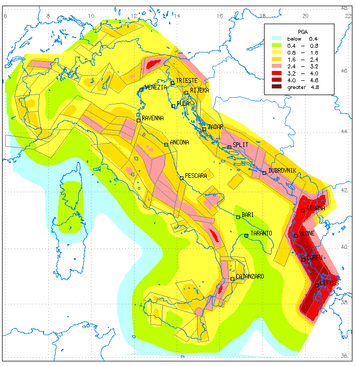
The conventional results of the seismic hazard evaluation in the Adria region are given in Fig. 6, 7 and 8 where the values of, respectively, PGA, spectral acceleration at 0.3 seconds (SA(0.3)), and spectral acceleration at 1.0 second (SA(1.0)) are reported. All these maps, which refer to rock, have been computed for a return period T=475 years (corresponding to the 90% non-exceedance probability in 50 years), and the uncertainty in attenuation is taken into account. The results have been masked outside of the test area by a gray overlaid pattern. In fact, (as it already described) some background SZ's have been designed to take into account only the contribution inside the test area limits of external seismicity: both their geometry and their seismicity characterization are rough.
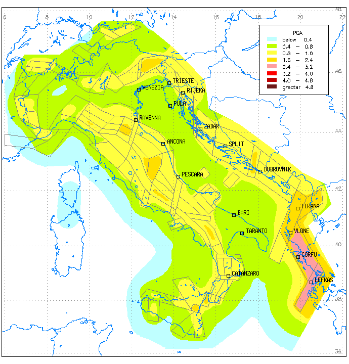
Fig. 6 indicates the PGA values which show that the maximum expected hazard is located around the Ionian islands, by far the highest seismic area along the Adriatic Sea. PGA values larger than 4.0 m/s2 are expected from southern Albania to Cephalonia. Most of the eastern coast of the Adriatic Sea has higher than 2.0 m/s2 PGA values, with a gap in correspondence to northern Dalmatia. Most of the Italian peninsula shows values which are larger than 1.6 m/s2, with local maxima of about 3.0 m/s2 located in central Italy, and slightly higher ones along the southern Apenninic arc. Another significant maximum, exceeding 3.2 m/s2, is located in northeastern Italy. Very few areas can be considered safe, in terms of seismic hazard; part of northwestern Italy, the Apulian peninsula, and part of Sicily, where values less than 0.8 m/s2 are expected. Only Sardinia is well under these values.
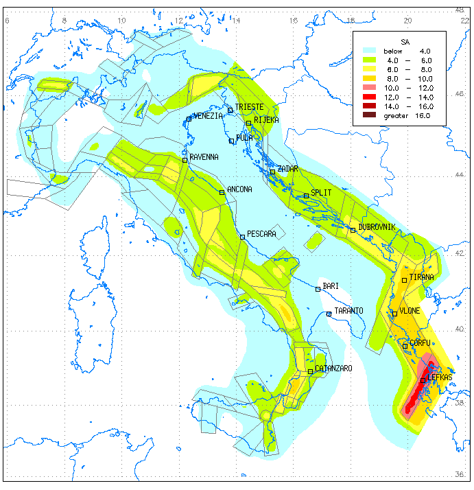
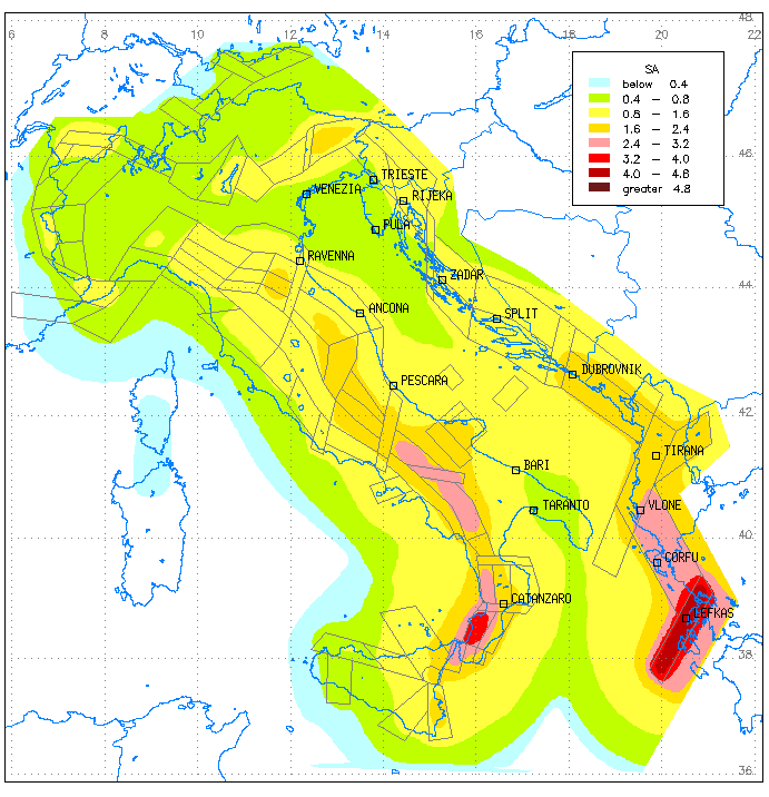
The comparison of the two spectral maps (Figs. 6 and 7) clearly shows the difference in contribution of long-term, high magnitude seismicity, with respect to a frequent but moderate one. The map of SA(0.3) shows a similar distribution of maxima as the PGA map (Fig. 6) does, even if the expected values are more than double. When SA(1.0) is considered, the seismic hazard in southern Italy, and the Ionian islands becomes more similar, as in both these areas high magnitude has been modelled by seismicity rates, causing the highest values of SA in the low frequency range.
In addition, Fig. 9 represents the PGA value at T=100 years, corresponding to 90% non-exceedance probability in about 10 years, another conventionally used period to represent the hazard results, expecially if the analysis is focused on damaging, and not collapse conditions. It is interesting to consider this shorter return period (T=100) to see the influence of the characteristic seismicity on the results too: in Fig. 9, the location of the maxima, in fact, is quite different from Fig. 6. Southern Albania and Greece confirm their importance, but some other areas where the expected values exceed 1.6 m/s2 become evident; see, for example, the Messina Straits, central Apennines, and southern Dalmatia.
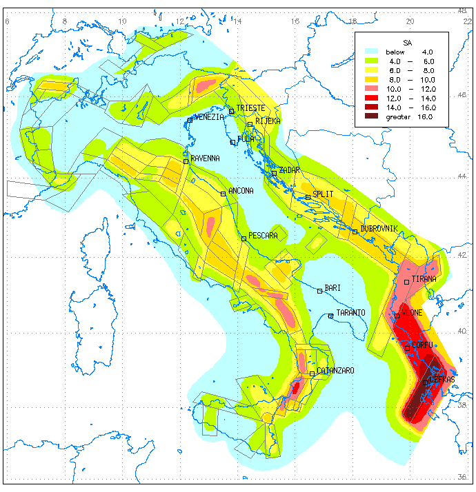
Soft soil conditions have also been considered and
Fig. 10 represents SA(0.3), with T=475 years. It is shown here because
the mapped values can be considered the highest predicted ones. Obviously
these analyses do not supply microzonation studies, or more detailed controls
of local conditions: they can, on the contrary, give a tentative indication
of the reliability of the estimates, when different, even if schematic,
soil conditions are taken into account.
7.2. Uniform hazard response spectra
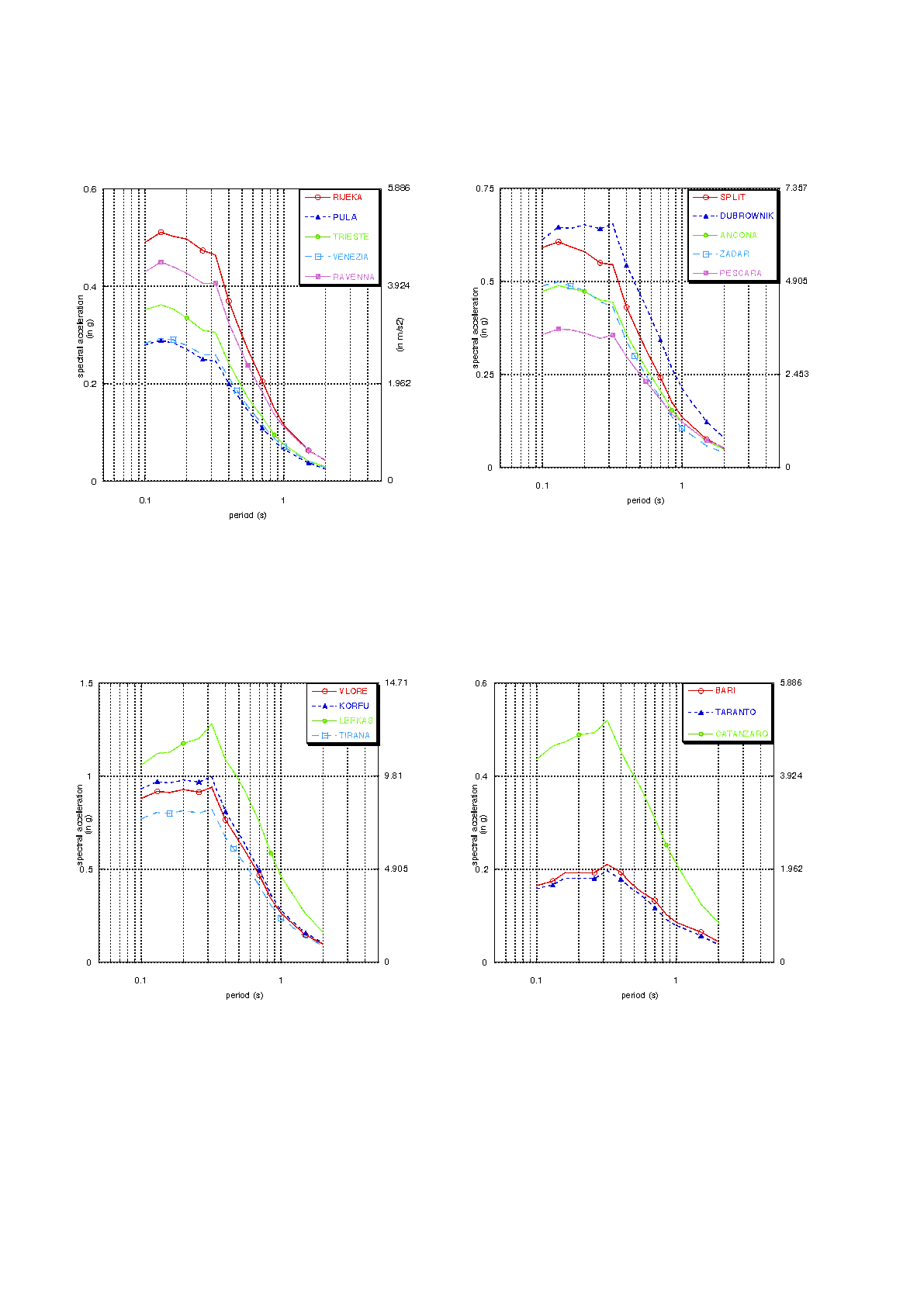
To conclude, Fig.11 collects the uniform hazard response
spectra referred to some major towns along the Adriatic coasts. They refer
to rocky sites, T=475 years, and were calculated using 14 sampled periods
in the range of 0.1 - 2.0 s; sa in the spectral attenuation relationships
is considered, even if the different values of standard deviation, defined
for each frequency (see Ambraseys et al., 1996) clearly introduce a modification
of the original spectral shape. This is the meaning, for example, of the
peaked values at 0.22 s, dependent on the higher uncertainty associated
to that frequency and not related to the characteristic seismicity affecting
the sites. The sites are grouped according to their geographical position.
In Fig. 11a the northern Adriatic cities are represented, as all characterized
by a medium to low seismic hazard. In the central Adriatic Sea (Fig. 11b)
the hazard increases: note the similar behaviour of Ancona and Zadar, facing
each other on the opposite sides of the sea. Then we assist an increase
of hazard going southwards along the Balkan coast, while a decrease is
expected along the Italian coast. Fig. 11c, represents the southernmost
towns of Adria along the Balkan coast, while Fig. 11d collects the Italian
towns. They show that the minimum and maximum seismic hazard estimates
refer to cities almost facing each other, along the Otranto Channel. The
deformation in Italy is westwards migrated, leaving Apulia in relatively
safe conditions.
8. Conclusions
The results of the GSHAP project for the Adria test area have been shown and the statistical aspects discussed. The probabilistic approach followed in the GSHAP project framework is consolidated and the main results (maps in Figs. 5 to 7) are in agreement with the standards of the European seismic code (Eurodode8-Part 5, 1994) for seismic zonation (map in terms of PGA) and worldwide accepted standards in seismic engineering (spectral maps). Additional maps (Figs. 8 and 10) represent additional information on seismic hazard of the study region.
Southern Albania and the Ionian islands represent the region with the highest hazard according to all the elaborations carried out. In the Apennines different segments are highlighted by the different elaborations but the southernmost part always reveals a high hazard.
The Adria project has benefitted from several positive situations: the recent conclusion of the hazard project for the revision of the Italian zonation, the set up of common data banks developed in the framework of European projects (e. g.: the European earthquake catalogue, the strong motion data bank, etc.,), and the vast improvement of seismotectonic knowledge, in all the countries involved in this project.
Nevertheless, some limits can be found in the present hazard assessment. The seismogenic zonation has been defined for Italy and for the coastal strip while the contribution from the inner Balkan region was modelled using schematic background zones. Some improvements on the zonation along the Balkan coast could favour homogeneity in the global zonation and could lead to an enlargment of the hazard results inland. The seismicity in the central Adriatic Sea remains badly documented and, consequently, the seismogenesis is roughly schematized. This is even more relevant in the Ionian Sea and, therefore, the southern margin of Adria is proposed without strong seismological constraints. Concerning the earthquake catalogue, hypocentral location is still an open problem for about 20% of the data, but the major uncertainty regards magnitude estimates. Magnitude determinations based on historical macroseismic data suffer of large uncertainties but some recent procedures tend to limit the subjective choices and the consequent systematic under or over estimations. On the contrary, instrumental data are usually considered error-free, and this contrasts dramatically with experience: the missing specification of the magnitude type, and the rarely given standard error in the estimate, may lead to inadequate treatments of this fundamental parameter. In this sense the present hazad results, which emphasise the esternmost part of Adria, are explaned. This is a general problem: in Europe the long lasting tradition in seismometric measurements can be a valid aid to magnitude calibration, and sooner or later the scientific community should face this problem, as its relevance in terms of human impact is great.
In conclusion, we believe that seismic hazard for
Adria represents a benchmark in the philosophy of hazard computation: our
experience states that, neither sources without kinematics behind, nor
earthquake catalogues without specific hazad purposes can lead to reliable
results, which, anyway, can always be improved.
Acknowledgements
The Adria project has been supported financially
by GNDT and GSHAP. Preliminary results from the BEECD project have been
used in this study and M. Stucchi and his partners are acknowledged. Many
thanks are due to P. Augliera and D. Spallarossa, for declustering the
Balkan part of the Adria catalogue.
REFERENCES
Algermissen, S.T., Perkins, D.M., Isherwood, W., Gordon, D., Reagor, G. and Howard, C., 1976. Seismic risk evaluation of the Balkan region. In: Karnik V. and Radu C. (eds), Proceedings of the Seminar on Seismic Zoning Maps, Vol. 2, Unesco, Skopje, pp. 172 - 240.
Ambraseys N.N. and Bommer J.J.; 1991: Database of European strong ground-motion records. European Earthquake Engineering, 5/2, 18 - 37.
Ambraseys N. N., Simpson K. A. and Bommer J. J.; 1996: Prediction of horizontal response spectra in Europe. Earth. Eng. Struct. Dyn., 25, 371-400.
Anderson, H. and Jackson, J.; 1987. Active tectonics of the Adriatic region. Geophys. J. R. Astr. Soc., 91, 937 - 983.
Anzidei M., Baldi P., Casula G., Pondrelli S., Riguzzi S., and Zanutta A.; 1997; Geodetic and seismological investigation in the Ionian area. Annali di Geofisica, 40, 1007-1017.
Bender B. and Perkins D.M. (1987). Seisrisk III: a computer program for seimic hazard estimation. U.S. Geological Survey Bulletin 1772, 48 pp.
Bragato P. L.; Bernardis G., Bressan G., Candido M., Durì G., Govoni A., Ponton F., Slejko D., Snidarcig A. and Urban S.; 1998: The Bovec earthquake of April 12, 1998: preliminary analysis of the seismological data. In: 26th General Assembly of the European Seismological Commission (ESC). Abstracts, ElAl, Tel Aviv, pp. 13.
Bressan G., Snidarcig A. and Venturini C.; 1998: Present state of tectonic stress of the Friuli area (eastern Southern Alps). Tectonophysics, 292, 211 - 227.
Camassi R. and Stucchi M.; 1996: NT4.1 un catalogo parametrico di terremoti di area italiana al di sopra della soglia del danno. C.N.R. GNDT, Milano, 86 pp.
Console R., Di Giovambattista R., Favali P., Presgrave B.W. and Smriglio G.; 1993: Seismicity of the Adriatic microplate. Tectonophysics, 218, 343 - 354.
Console R., Di Giovambattista R., Favali P. and Smriglio G.; 1989: Lower Adriatic sea seismic sequence (January 1986): spatial definition of the seismogenic structure. Tectonophysics, 166, 235 - 246.
Console R., Di Giovambattista R., Favali P. and Smriglio G.; 1992: Seismogenic structures activated during the 1987 seismic sequences along the Adriatic coast. Geophys. J. Int., 108, 379 - 386.
Console R. and Favali P.; 1981: Study of the Montenegro earthquake sequence (March - July 1979). Bull. Seism. Soc. Am., 71, 1233 - 1248.
Console, R. and C. Gasparini (1977): Le scale macrosismiche (Ist. Naz. Geofisica, Roma) pp. 1 - 21.
Cornell C.A. (1968). Engineering seismic risk analysis. Bull. Seism. Soc. Am., 58, 1583-1606.
Del Ben A., Finetti I., Rebez A. and Slejko D.; 1991: Seismicity and seismotectonics at the Alps - Dinarides contact. Boll. Geof. Teor. Appl., 33, 155 - 176.
Eurocode8-Part5; 1994: Design provisions for earthquake resistance of structures. Part 5: foundations, retaining structures and geotechnical aspects. Doc. ENV 1998-5, CEN European Committee for standardization, Bruxelles.
Eva E., Solarino S., Eva C. and Neri G.; 1997: Stress tensor orientation derived from fault plane solutions in the southwestern Apls. J. Geophys. Res., 102, B4, 8171-8185.
Favali P., Funiciello R., Mattietti G., Mele G.and Salvini F.; 1993: An active margin across the Adriatic sea (central Mediterranean sea). Tectonophysics, 219, 109 - 117.
Frepoli A. e Amato A., 1997. Contemporaneous extension and compression in the Northern Apennines from earthquake fault-plane solutions. Geophys. J. Int., 129, 368-388.
Gardner J.K. and Knopoff L.; 1974: Is the sequence of earthquakes in southern California, with aftershocks removed, Poissonian? Boll. Seism. Soc. Am., 64, 1363 - 1367.
Giardini D. and Basham P.(eds); 1993: Global Seismic Hazard Assessment Program. Annali di Geofisica, 33, n. 3 - 4.
Herak, M., 1995. Earthquake catalog of Croatia and adjacent regions, Archives of the Andrija Mohorovicic Geophysical Institute, Zagreb.
Herak M., Herak D. and Markusic S.; 1995: Fault-plane solutions for earthquakes (1956-1995) in Croatia and neighbouring regions. Geofizika, 12, 43-56.
Herak, M., Herak, D., and S. Markusic; 1996: Revision of the earthquake catalogue and seismicity of Croatia, 1908-1992. Terra Nova, 8, 86-94.
Herak D., Herak M., Prelogovic E. and Cabor S.; 1988: Some characteristics of the Adriatic sea earthquake sequence (January - February 1986). Boll. Geof. Teor. Appl., 30, 385 - 394.
Lapajne J. K., Sket Motnikar B. and Zupancic P.; 1997: Preliminary seismic hazard maps of Slovenia. Natural Hazards, 14, 155 - 164.
Lee, V.W.: 1995: Pseudo relative velocity spectra in former Yugoslavia. Eur. Earthquake Eng., 8, 12 - 22.
Lee, V.W. and Trifunac, M.D.: 1992: Frequency dependent attenuation of strong earthquake ground motion in Yugoslavia. Eur. Earthquake Eng., 6, 3 - 13.
Legros, Y. and Bonnin, J., 1996. Seismicity (IBCM-S) Explanatory booklet. European-Meditarranean Seismological Centre, International Bathymetric Chart of the Meditarranean (IBCM). 52 pp.
Louvari E. K., Kiratzi A. A. and Papazachos B. C.; 1997: Further evidence for strike-slip faulting in the Ionian islands: the Lefkada fault. In: The 29th General Assembly of IASPEI, Abstracts, P. Ziti & Co., Thessaloniki, pp. 111.
Makropoulos, K.C. and Burton P., 1981. A Catalogue of Seismicity in Greece and Adjacent Areas. Geophysical Journal of the Royal Astronomical Society, 65, pp. 741-762
Makropoulos, K.C. and Burton, P.W.: 1985b, Seismic hazard in Greece. II. Ground acceleration, Tectonophysics, 117, 259-294.
Mantovani E., Albarello D. and Mucciarelli M., 1987. Interrelation between the seismicity of the Calabrian and Balkan areas. Annales Geophysicae, 2, 143-148.
Meletti C., Patacca E., Scandone P., 1998. Construction of a seismotectonic model: the case of Italy. Pageoph, in press.
Muco B.; 1997: The Shkoder - Peja transcurrent fault (northern Albania) and its seismic activity, 1976 - 1995. In: The 29th General Assembly of IASPEI, Abstracts, P. Ziti & Co., Thessaloniki, pp. 285.
Neri G., Caccamo d., Cocina O., Montalto A.; 1996: Geodynamic implications of recent earthquake data in the Southern Tyrrhenian Sea. Tectonophysics, 258, 233-249.
Pantosti D., Schwartz D. P., and Valensise G.; 1993: Paleoseismology along the 1980 Irpinia earthquake fault and implications for eathquake recurrence in the southern Apennines. J. Geophys. Res., 98, 6561-6577.
Papazachos, B. and Papazachou, K., 1989. The earthquakes of Greece. Ziti Publ., Thessaloniki, 356 pp.
Peruzza L., Iliceto V. and Slejko D.; 1989: Some seismotectonic aspects of the Alpago - Cansiglio area (N.E. Italy). Boll. Geof. Teor. Appl., 31, 63-75.
Peruzza L., Rebez A. and Slejko D.; 1997: Seismic hazard assessment for the Adria region. In: The 29th General Assembly of the International Association of Seismology and Physics of the Earth's Interior, Abstracts, Ziti & Co., Thessaloniki, pp. 385.
Peruzza L., Rebez A and Slejko D.; 1998: Probabilistic seismic hazard spectra for the Adriatic region. In: Bisch P., Labbè P. and Pecker A. (eds), Proceedings of the Eleventh European Conference on Earthquake Engineering, Abstract volume and CD-ROM, pp. 48 and CD-ROM.
Renner G. and Slejko D.; 1994: Some considerations on the seismicity of the Adriatic region. Boll. Geof. Teor. Appl., 36, 381 - 398.
Renner G. and Slejko D.; 1998: Stress tensor computation for the Adriatic region. In: Neri G. and Eva C. (eds), Earthquake plane solutions: databases, derived parameters, geodynamic inferences. Segraf, Messina, pp. 60 - 65.
Ribaric, V., 1982. Seismicity of Slovenia. Catalogue of Earthquakes (792 A.D.-1981). Ljubljana, 649 pp.
Rock N. M. S.; 1988: Numerical geology. Springer Verlag, Berlin, 427 pp.
Sabetta F. and Pugliese A. (1987). Attenuation of peak horizontal acceleration and velocity from Italian strong-motion records. Bull. Seism. Soc. Am., 77, 1491-1513.
Sabetta F. and Pugliese A,; 1996: Estimation of response spectra and simulation of nonstationarity earthquake ground motion. Bull, Seism. Soc. Am., 86, 337 - 352.
Scandone P., Patacca E., Meletti C., Bellatalla M., Perilli N. e Santini U.; 1992: Struttura geologica, evoluzione cinematica e schema sismotettonico della penisola italiana. In: GNDT, Atti del Convegno 1990 Vol. 1 Zonazione e riclassificazione sismica, Ed. Ambiente, Bologna, pp. 119 - 135.
Shebalin, N.V., Karnik, V. and Hadzievski, D. (eds.), 1974. Catalogue of earthquakes of the Balkan region. I, UNDP- UNESCO Survey of the seismicity of the Balkan region. Skopje, 600 pp.
Slejko D.; 1994: The GSHAP Adria project. In: Makropoulos K. and Suhadolc P. (eds), ESC XXIV General Assembly, 1994 September 19 - 24, Athens, Greece, Proceedings and Activity Report 1992 - 1994, vol. III, pp. 1549 - 1558.
Slejko D., Peruzza L. and Rebez A.; 1998a: Different aspects and considerations on seismic hazard in the Adriatic region. Annales Geophysicae, supplement 1 to vol. 16, 23rd EGS General Assembly Nice 20 - 24 April 1998, c19.
Slejko D., Peruzza L. and Rebez A.; 1998b: Seismic hazard maps of Italy. Annali di Geofisica, 41, 183 - 214.
Stucchi M. (ed); 1998: BEECD A basic European earthquake catalogue and a database for the evaluation of long-term seismicity and seismic hazard. Final Report (draft), Annexes and CD ROM. CNR - IRRS, Milano.
Sulstarova, E. and Kociu, S., 1975. The catalogue of Albanian earthquakes. Botim i Qendres Sizmologjike Tirane, 223 pp.
Sulstarova E., Peci V. and Shuteriqi P.; 1997: Vlora - Elbasan - Diber transversal fault and its seismic activity. In: The 29th General Assembly of IASPEI, Abstracts, P. Ziti & Co., Thessaloniki, pp. 115.
Tento A., Franceschina L. and Marcellini A.; 1992: Expected ground motion evaluation for Italian sites. In: Proc. 10th World Conf. Earth. Eng., Madrid, vol. 1, pp. 489 - 494.
Ward S. N.; 1994: Constraints on the seismotectonics
of the Central Mediterranean from very long base interferometry. Geophys.
J. Int., 117, 441-452.
Fig. 2. Fault plane solutions for major earthquakes in Adria. Black baloons indicate events with magnitude of 6 and more, grey baloons show events with magnitude exceeding 5.5.
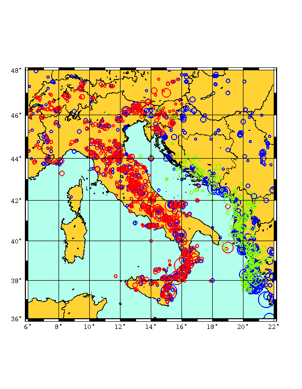
Fig. 3. Epicentre distribution of earthquakes with magnitude larger than, or equal to, 5.5 in Adria. Colors indicate the catalogue from which the data come from: red = NT.4.1 (Camassi and Stucchi, 1996); blue = BEECD (Stucchi, 1998); green = this work (this century).
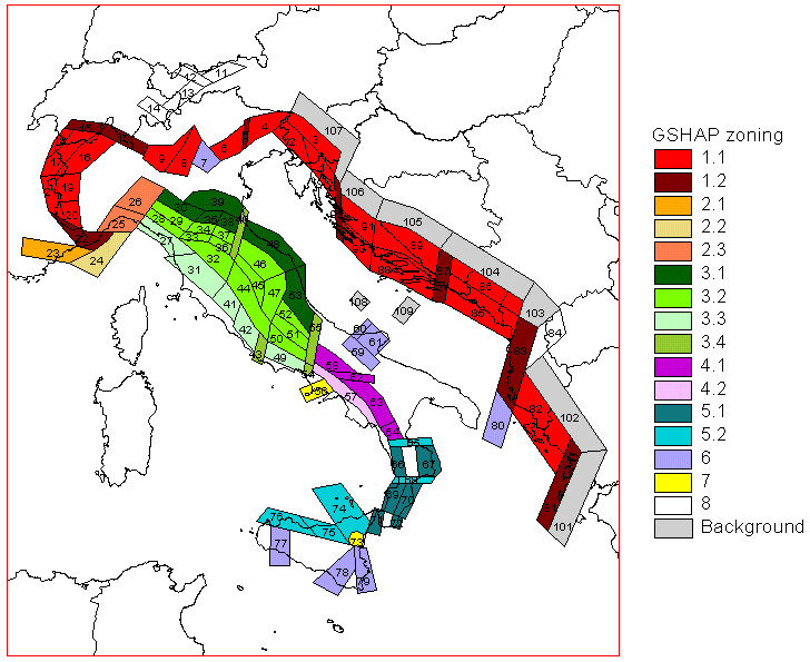
Fig. 4. Seismogenic zonation of Adria and surrounding regions.
1. Seismic source zones related to the interaction between Adria and Europe (from the Alps to the Western Hellenides). The P-axes of the major earthquakes agree with the slip vectors describing the Adria rotation around a pole located between Corsica and Western Liguria.
1.1 Longitudinal belts. Expected focal mechanisms (Efm): thrust and transpression.
1.2 Transversal belts, corresponding to lateral ramps. Efm: transpression/strike slip, with dextral (zones 15, 10, 1, 87, 83, 81) and sinistral (zones 22, 5) lateral motion.
2. Alps/Apennine transfer zones.
2.1 Shear zones of Western Liguria. Efm: sinistral strike slip and transpression.
2.2 Ligurian Sea,with compressional structures overprinting extensional features. Efm: thrust and sinistral strike slip.
2.3 Liguria-Langhe. Efm: sinistral strike slip (shallower crustal earthquakes), dip slip (deeper crustal quakes).
3. Seismic source zones related to the sinking of the Adria lithosphere beneath the Northern Apennine Arc and to the uplift of the asthenosphere along the Tyrrhenian margin of the mountain chain.
3.1 Adriatic longitudinal belt. Efm: thrust and strike slip with SW-NE P-axes.
3.2 North-Apennine axial belt. Efm: prevailing dip slip with fault planes dipping both towards the Adriatic and Tyrrhenian seas.
3.3 Tyrrhenian longitudinal belt. Efm: dip slip with fault planes dipping towards SW.
3.4 Transversal belts. Efm: prevailing dextral strike slip; subordinate dip slip in the deeper crustal earthquakes.
4. Seismic source zones related to the deactivation of the thrust belt - foredeep system in the Southern Apennnines and to the counterclockwise rotation of Adria.
4.1 South Apenninie axial belt. Efm: dip slip with fault planes dipping both towards NE and SW; subordinate strike slip.
4.2 Tyrrhenian belt. Efm: dip slip.
5. Seismic source zones of the Calabrian Arc. It is still matter of debate whether the present-day kinematic behaviour of the Calabrian Arc is comparable with zone 2 or with zone 3.
5.1 Longitudinal belts. Efm: prevailing dip slip.
5.2 Transversal belts. Efm: dextral (e.g. zone 74) and sinistral (e.g. zone 65) strike slip.
6. Seismic source zones inside the foreland region and along the flexural margins.
Belice, Hyblean margin, Malta Escarpment, Otranto Channel, Gargano-Tremiti, Vicentino. Efm: prevailing dip slip in the flexural areas (e.g. zone 78) and along the Malta Escarpment; strike slip in the other areas.
7. Seismic source zones in active volcanic regions.
Ischia-Flegrean Fields, Vesuvius and Etna. Efm: dip slip in
the Campania volcanic region; dip slip and dextral strike slip in the Etna
region.
Fig. 6. PGA (in m/s2) with a 475-year return period for Adria.
Fig. 7. SA(0.3) (in m/s2) with a 475-year return period for Adria, rocky soil.
Fig. 8. SA(1.0) (in m/s2) with a 475-year return period for Adria, rocky soil.
Fig. 9. PGA (in m/s2) with a 100-year return period for Adria.
Fig. 10. SA(0.3) (in m/s2) with a 475-year return period for Adria, soft soil.
Fig. 11. Uniform hazard spectra for the major towns along the Adriatic coast.