Seismic Hazard Assessment of Iran
B.Tavakoli and M. Ghafory- Ashtiany
International Institute of Earthquake Engineering and Seismology (IIEES),
P.O.Box 19395/3913 Tehran, I.R.IRAN
Tel: +98 21 2294932; Fax: +98 21 2299479
Email: tavakoli @ dena.iiees.ac.ir
Abstract
The development seismic hazard map of Iran is based on probabilistic seismic hazard computation using the historical earthquakes data, geology, tectonics, fault activity and seismic source models in Iran. These maps have been prepared to indicate the earthquake hazard of Iran in the forms of iso-acceleration contour lines, and seismic hazard zonations by utilizing to current probabilistic procedures. They contain the probabilistic estimates of Peak Ground Acceleration for the return periods of 75 and 475 years. The map has been divided into intervals of 0.25 degrees in both latitudinal and longitudinal directions for calculating the peak ground acceleration values at each grid point and drawing seismic hazard curves. The results presented in this study are to provide a base for preparing of seismic risk map, the estimation of earthquake insurance premiums, and the preliminary site evaluation of critical facilities.
Introduction
The probabilistic assessment of the seismic hazard in Iran involves specifying the likelihood, magnitude, location, and nature of earthquakes that might have damaging effect in the region or at the site and estimating the peak acceleration of the ground shaking. The basis for all seismic hazard assessment is the analysis of seismicity or the occurrence of earthquake in space and time. The term seismicity in this study has been used to describe different parts of earthquake record. These parts include: 1) the pre-historic and historical seismicity data (pre-1900), 2) The instrumental seismicity data (1900-1997), and 3) Seismic sources of the historical and instrumental earthquakes, rate of activity, and fault interaction. Accurate knowledge of seismicity is an important tool for understanding active tectonics.
Seismic hazard analysis require an assessment of the future earthquake potential in Iran. It is, therefore, necessary to estimate the maximum earthquake magnitude and recurrence character that might be generated by a particular active fault. The most common uses of more detailed geologic data have been to constrain maximum earthquake magnitudes using empirical relationships between earthquake rupture dimensions and magnitude .
One of the basic elements in assessing seismic hazards is to recognize seismic sources that could affect the particular location at which the hazard is being evaluated. These sources are often called seismotectonic sources. Defining and understanding seismotectonic sources is often the major part of a seismic hazard analysis and requires knowledge of the regional and local geology, seismicity, and tectonics. Two types of seismotectonic sources were identified in this study, fault or line sources, which may be sources of future earthquakes, and localizing structures and seismotectonic provinces which appear as area sources.
In this study, the geological and seismological data were integrated into a probabilistic seismic hazard model for Iran which located between 25 to 40 degrees N and 44 to 63 degrees E.
The main steps and parameters of the probabilistic seismic hazard assessment conducted in this study have been summarized as follows:
Earthquake Data Base
A review of Iran’s historical earthquakes (Pre-1900) is provided by Ambraseys and Melville (1982). To improve the quality and accuracy of these earthquake data the new Earthquake Catalogue of Iran has been compiled by Berberian in 1994. For present century, IIEES catalogue based on reports from international seismological institutes have been used..
With the inception of seismological stations, the location accuracy of the earthquakes has considerably improved after mid 1960’s. Thus, especially for Iran, it can be stated that the reliable earthquake data base exists only for the last several decades. Both of these catalogues have provided a base for the spatial correlation of the seismicity with the seismotectonic sources in Iran.
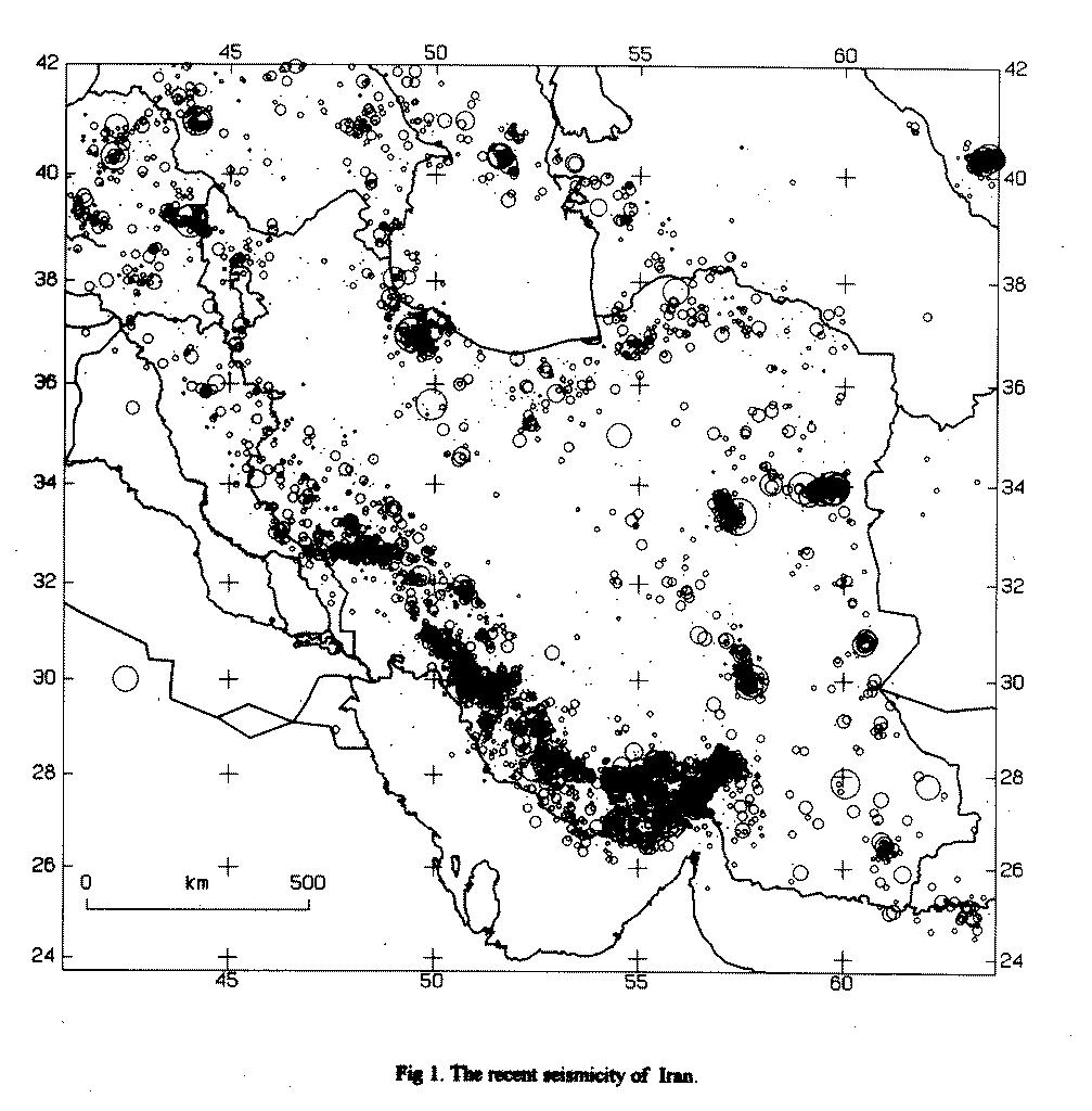
From 1930 to 1985, the seismicity analysis of Iran was conducted by Wilson(1930), Niazi and Basford (1968), Nowroozi (1972, 1976), Banisadr (1971), Ambraseys and Moinfar (1973), Berberian (1973) and Tchalenko (1975). It is now agreed by several investigators that the seismicity in Iran is related to the local surface geology and tectonics. Many destructive earthquakes such as Silakhor(Ms=7.4, 1909), Salmas (Ms=7.4, 1930), Torud(Ms=6.4, 1953), Lar(Ms=6.7, 1960), Buyin Zahra (Ms=7.2, 1962), Dasht-e-Bayaz (Ms=7.4, 1968), Qir(Ms=6.9, 1972), Khorgu(Ms=7, 1977), Tabas(Ms=7.7, 1978), Qayen(Ms=7.1, 1979), Rudbar-Manjil(Ms=7.2, 1990), and Birjand (Ms=7.3, 1997) confirm this phenomenon in Iran. Therefore, the Iranian plateau is one of the seismically active areas of the world and frequently suffers destructive and catastrophic earthquakes that cause heavy loss of human life and widespread damage. Figure (1) indicates the recent seismicity of Iran. It shows the high inhomogeneouty and seismic activity dispersion of the Iranian plateau. No earthquakes larger than Ms=7.0 have been experienced in the Zagros region during the 20th century, but shocks of magnitude over Ms=7.0 have occurred in central and eastern Iran.
Seismotectonic Provinces of Iran
The Iranian plateau can be characterized by active faults, recent volcanic and high surface elevation along the Alpied earthquake belt. Tectonic studies indicate that the Iranian plateau has a very high density of active and recent faults. Earthquake data of Iran show that most activity is concentrated along the Zagros fold thrust belt while less activity is observed in central and eastern Iran. Thus, several regions are vulnerable to destructive earthquakes. The preparation of an earthquake hazard map is the delineation of the seismotectonic province and the assessment of the associated maximum earthquake potentials. They can be defined as a geographic region of some geological, geophysical and seismological similarity with the assumption of uniform earthquake potential. Earthquakes are assumed to occur randomly throughout the seismotectonic provinces event though the earthquake record may indicate some clustering at preferred locations. The seismotectonic province of Iran is defined as an area bounded by geological features which mark a difference in seismic characteristics of one province from its neighboring provinces. Each province has equal seismic potential and uniform geological structure and trends.
The seismotectonic structure of Iran was studied by several investigators in the past. Stoklin(1968), Takin(1972), and Berberian (1976) have suggested simplified divisions consisting of only nine, four, and four regions, respectively. A more elaborated division, consisting of twenty-three seismotectonic provinces was suggested by Nowroozi (1976). In the present work, a modified and updated catalogue of large and damaging Iranian earthquakes has been prepared to provide a based for the correlation between seismic activity and seismotectonic provinces. On this basis, the new seismotectonic provinces have been proposed by Tavakoli (1996).
The boundaries of the provinces are established through analysis of seismic history, relocated epicenter for the past several decades, tectonic environments, active faults, regional geomorphology, and plate boundaries. Tavakoli (1996) has divided Iran into 20 seismotectonic provinces, as it has been shown in Figure(2). The activity faults are located in parts of twenty known seismotectonic provinces of Iran.
Earthquake Hazard Parameters
Earthquake hazard analysis requires and assessment of earthquake hazard parameters and the future of earthquake potential in a region. Earthquake hazard parameters such as, maximum expected magnitude, Mmax, activity rate, ![]() , and b value of the Gutenberg-Richter relation have been evaluated for each seismotectonic province of Iran. The applied maximum likelihood method used in this study (Kijko and Sellevoll, 1992) permits the combination of both historical and instrumental data. The maximum likelihood estimation for fitting the seismicity parameter
, and b value of the Gutenberg-Richter relation have been evaluated for each seismotectonic province of Iran. The applied maximum likelihood method used in this study (Kijko and Sellevoll, 1992) permits the combination of both historical and instrumental data. The maximum likelihood estimation for fitting the seismicity parameter ![]() has a good applicability correlation with the Iranian earthquake data. This is due to the fact that earthquake magnitudes have always been reported by some uncertainty. In this method also artificially homogeneous data set is simulated through the determination of the period over which the data in a given time span are completely reported. In the present study, unlike previous works, seismic gaps, i.e., when records are missing or the seismic network was not in operation, and uncertainties of earthquake magnitudes are considered in analysis. This consideration is necessary for regions like Iran where few Earthquake data base are available.
has a good applicability correlation with the Iranian earthquake data. This is due to the fact that earthquake magnitudes have always been reported by some uncertainty. In this method also artificially homogeneous data set is simulated through the determination of the period over which the data in a given time span are completely reported. In the present study, unlike previous works, seismic gaps, i.e., when records are missing or the seismic network was not in operation, and uncertainties of earthquake magnitudes are considered in analysis. This consideration is necessary for regions like Iran where few Earthquake data base are available.
Therefore, based on the collected data, the earthquake hazard parameters, as shown in Table 1, were estimated for each seismotectonic province of Iran. It should be noted that in this work, the Gutenberg-Richter parameters was assumed to be constant for each province.
Attenuation Relationships
Magnitude, distance and site conditions are the principal variables used in predicting future ground motions. A number of predictive relationships derived from regression analysis of strong motion data are available for peak horizontal ground acceleration. The analysis requires a seismic source model of the region and appropriate attenuation relationships. It was decided to use the Campbell (1990) and Campbell-Bozorgnia (1993) attenuation relationships in this study. These relationships were derived empirically from recorded accelerograms due to earthquakes in different parts of the world. Most of these accelerograms used to drive these relationships are recorded in Western North America, and some other part of the world (including the Tabas and Manjil earthquake in Iran). However, Chandra et. al (1979) show that attenuation of acceleration is more rapid in Iran than Western North America. Therefore, the use of these relationships may be conservative. It should be noted that Zare, Bard, and Ghafory-Ashtiany are developing an attenuation law for Iran based on a new corrected strong motion accelerometer data base. However, it was not ready to be used for this hazard assessment. Therefore, these relationships have been accepted as appropriate models for evaluation of the ground motion parameters in the seismic zonations study.
Approach and Results of Hazard Analysis
For probabilistic seismic hazard assessment SEIS RISK III (A Computer Program for Seismic Hazard Estimation) was used to calculate peak ground acceleration. The calculated values for earthquake hazard are displayed as iso-acceleration contours expected to be exceeded during typical economic life time of structures. This program is based on the assumption that the site acceleration has a Poisson distribution with a mean annual rate. The program can accommodate any attenuation relationships in digitized format and generate a table of peak ground accelerations and the cumulative distribution of the acceleration for each specified site. It is also capable of modeling acceleration variability and permits the option of earthquake location uncertainty, as well as smooth variation of seismicity across the boundaries of the zone.
Probabilistic ground motion analysis were made for sites located throughout the region on a 0.25 o X 0.25 o grid and drawing seismic hazard curves. Figure (3) shows the iso-acceleration lines for the return periods of 75 and 475 years. Figure (4) shows the seismic hazard zonations map of Iran. As shown on Figure (4), four zones were defined for zonation mapping of the region. The defined zones were rated as: very high hazard, high hazard, moderate hazard and low hazard.
Conclusions
Seismic hazard maps have been prepared to indicate the earthquake hazard of Iran in the forms of iso-acceleration contour lines, and seismic hazard zonation. These maps were originally presented on 1: 5,000,000 scale. Characteristic of these maps are as follows:
References
Fig 1. The recent seismicity of Iran.
Fig 2. Seismotectonic Provinces of Iran.
Table 1: Estimated earthquake hazard parameters for the twenty seismotectonic provinces.