Kaye M. Shedlock(1) and James G. Tanner(2)
(1) U.S. Geological Survey, Golden, CO, U.S.A.
(2) University of Western Ontario, ON, Canada
Abstract
Vulnerability to natural disasters increases with
urbanization and development of associated support systems (reservoirs,
power plants, etc.). Catastrophic earthquakes account for 60% of worldwide
casualties associated with natural disasters. Economic damage from earthquakes
is increasing, even in technologically advanced countries with some level
of seismic zonation, as shown by the 1989 Loma Prieta, CA, ($ 6 billion),
1994 Northridge, CA, ($ 25 billion), and 1995 Kobe, Japan, (> $ 100 billion)
earthquakes. The growth of megacities in seismically active regions around
the world often includes the construction of seismically unsafe buildings
and infrastructures, due to an insufficient knowledge of existing seismic
hazard. Minimization of the loss of life, property damage, and social and
economic disruption due to earthquakes depends on reliable estimates of
seismic hazard. National, state, and local governments, decision makers,
engineers, planners, emergency response organizations, builders, universities,
and the general public require seismic hazard estimates for land use planning,
improved building design and construction (including adoption of building
construction codes), emergency response preparedness plans, economic forecasts,
housing and employment decisions, and many more types of risk mitigation.
The seismic hazard map of the Americas is the concatenation of various
national and regional maps, involving a suite of approaches. The combined
maps and documentation provide a useful global seismic hazard framework
and serve as a resource for any national or regional agency for further
detailed studies applicable to their needs. This seismic hazard map depicts
Peak Ground Acceleration (PGA) with a 10% chance of exceedance in 50 years
for the western hemisphere. PGA, a short-period ground motion parameter
that is proportional to force, is the most commonly mapped ground motion
parameter because current building codes that include seismic provisions
specify the horizontal force a building should be able to withstand during
an earthquake. This seismic hazard map of the Americas depicts the likely
level of short-period ground motion from earthquakes in a fifty-year window.
Short-period ground motions effect short-period structures (e.g. one-to-two
story buildings). The largest seismic hazard values in the western hemisphere
generally occur in areas that have been, or are likely to be, the sites
of the largest plate boundary earthquakes. Although the largest earthquakes
ever recorded are the 1960 Chile and 1964 Alaska subduction zone earthquakes,
the largest seismic hazard (PGA) value in the Americas is in southern California
(U.S.), along the San Andreas fault.
Introduction
Seismic hazard maps depict the levels of chosen ground motions that likely will, or will not, be exceeded in specified exposure times. Hazard assessment programs in the region commonly specify a 10% chance of exceedance (90% chance on non-exceedance) of some ground motion parameter for an exposure time of 50 years, corresponding to a return period of 475 years. Commonly mapped ground motions are maximum intensity, peak ground acceleration (PGA), peak ground velocity (PGV), and several spectral accelerations (SA). Each ground motion mapped corresponds to a portion of the bandwidth of energy radiated from an earthquake. PGA and 0.2s SA correspond to short-period energy that will have the greatest effect on short-period structures (one-to two story buildings, which is the most common building stock in the region). Longer-period SA maps (1.0s, 2.0s, etc.) depict the level of shaking that will have the greatest effect on longer-period structures (10+ story buildings, bridges, etc.).
Each national or regional seismic hazard map in the Americas was produced using the methodology originally described by Cornell (1968). There are three major elements of this method: 1) the characterization of seismic sources; 2) the characterization of attenuation of ground motion; and 3) the actual calculation of probabilities. Variations in each element of seismic hazard assessment lead to differences in the estimated hazard along the national borders in North America. The hazard values for Central and South America were computed regionally, resulting in continuous hazard contours across national boundaries.
The first element of seismic hazard assessment, the characterization of seismic sources, involves obtaining ?robust? answers to three questions:
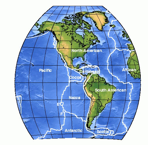
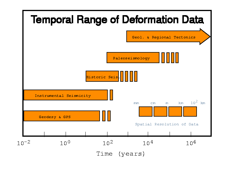
Ninety percent (90%) of all earthquakes occur along the plate boundaries (fig. 1). The Americas are the major landmasses of three plates (North and South American and Caribbean). Almost all of the known major earthquakes in the Americas have occurred along the western edges of these three plates, where they are overriding or sliding past the Pacific, Cocos, Nazca, and associated smaller plates (fig. 1). Seismicity catalogs are the fundamental tool used to determine where, how often, and how big earthquakes are likely to be. However, seismicity statistics are based on geologically short catalogs, so other deformation data are examined (fig.2).
The results from seismic monitoring, the historic record, geodetic monitoring, and the geologic record are combined to characterize seismic sources. Most countries in the Americas use these data to interpret seismic source zones (fig. 3). Because many interpretations of the input data are possible, there are large uncertainties associated with source characterization. Various schemes are invoked to either explicitly or implicitly include these uncertainties in seismic hazard calculations. For example, multiple source zone models may be defined. Hazard calculations from each model are then combined using various schemes that produce a weighted mean (or median) hazard value.
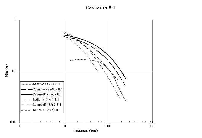
State-of-the-art estimates of expected ground motion at a given distance from an earthquake of a given magnitude are the second element of earthquake hazard assessments. These estimates are usually equations, called attenuation relationships, which express ground motion as a function of magnitude and distance (and occasionally other variables, such as type of faulting). Ground motion attenuation relationships (fig. 4) may be determined in two different ways: empirically, using previously recorded ground motions, or theoretically, using seismological models to generate synthetic ground motions which account for the source, site, and path effects. There is overlap in these approaches, however, since empirical approaches fit the data to a functional form suggested by theory and theoretical approaches often use empirical data to determine some parameters.
The parameters that must be clearly defined in order to estimate ground motions are: earthquake magnitude, type of faulting, distance, and local (receiver) site conditions (classification). Moment magnitude (M) is the preferred magnitude measure, because it is directly related to the seismic moment of the earthquake and does not saturate. Style of faulting needs to be specified because, within 100 km of a site, strike-slip earthquakes generate smaller ground motions than reverse and thrust earthquakes, except for M ? 8.0 (Boore et al., 1993; 1994; Campbell and Bozorgnia, 1994). Different researchers use different source-to-site distance measures. A complete summary can be found in Abrahamson and Shedlock (1997). There are also several site classification schemes, ranging from a description of the physical properties of near-surface material to very quantitative characterizations. Seismic hazard maps are calculated for a specific site classification (hard rock, soft rock, stiff soil, soil, soft soil, etc.). Hazard values calculated for rock/stiff soil sites (the most common site classifications) are lower than hazard values calculated for soil sites. Often, hazard values for soil sites my be estimated from the rock/stiff soil site values commonly depicted on hazard maps through multiplication by a specified factor, but these are no more than rough estimates. Summaries may be found in Borcherdt (1993) and Shedlock and Abrahamson (1997).
The third element of hazard assessment, the actual calculation of expected ground motion values, involves determining an annual frequency of exceedance of the ground motion parameter of interest, then summing over the time period of interest. The most commonly mapped ground motion parameters are horizontal and vertical peak ground acceleration (PGA), peak ground velocity (PGV), and 5%-damped spectral acceleration (SA) for a given site classification. Historically, maps of PGA values have formed the basis of seismic zone maps that are included in building codes, including the US Uniform Building Code. Current building codes that include seismic provisions specify the horizontal force a building should be able to withstand during an earthquake. PGA values are directly related to the lateral forces that damage short period structures (a single-family dwelling, i.e., the most common structure in any country). Maps of longer period spectral response ordinates (0.3s, 0.5s, 1.0s, 2.0s, etc.) are directly related to the lateral forces that damage larger structures with longer natural periods (apartment buildings, hi-rises, bridges).
The PGA seismic hazard map of the Americas is the
concatenation of various national and regional maps, involving a suite
of approaches. The methods and data used in the generation of each national
or regional map used to produce the seismic hazard map of the western hemisphere
are documented briefly herein, along with the names and contact information
for the scientists responsible for the maps. The user is encouraged to
contact the appropriate scientists and/or agencies for more detailed information.
North and Central America and the Caribbean
Shedlock (this volume, 1998) presents a summary of
the data and methods used to produce the seismic hazard map of North and
Central America and the Caribbean.
South America
Various researchers have published probabilistic
seismic hazard maps of countries or regions of South America. Centro Regional
de Sismologia para America del Sur (CERESIS) was established in 1971 to
coordinate and increase the observation, recording, analysis, and interpretation
of seismicity in South America. CERESIS published the first regional seismicity
catalogs and hazard maps in 1981. A complete summary of the current CERESIS
seismic hazard map may be found elsewhere in this volume (Giesecke et
al., 1998). CERESIS also cooperated with the Pan-American Institute
of Geography and History (PAIGH) to produce a seismic hazard map of the
region (Tanner and Shepherd, 1997). In 1995, researchers from four European-Mediterranean
(EUME) and five Andean Pact (JUNAC) countries formed the Pilot Project
for Regional Earthquake Monitoring and Seismic Hazard Assessment (PILOTO).
Among the many achievements of this group is a Andean region seismic hazard
map. A complete summary of the PILOTO seismic hazard map may be found elsewhere
in this volume (Dimatè et al., 1998). The seismic hazard
map of South America included in this report is a combination of the maps
produced under the auspices of PAIGH and PILOTO. Herein, we describe the
data and methods used to produce the PAIGH and the combined seismic hazard
maps.
Seismicity
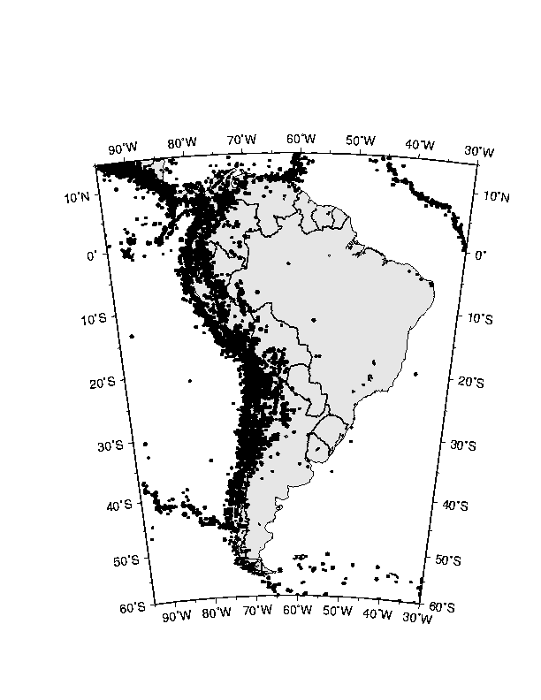
Seismicity in South America is concentrated along the South American/Caribbean /Cocos/Nazca (and associated smaller) plate boundaries (fig. 5). The largest earthquake ever recorded occurred along the coast of Chile in 1960 (M = 9.5; Kanamori, 1977). During the twentieth century, earthquakes with M > 8 have been recorded along the coasts of Ecuador (1906), Chile (1906, 1922, and 1943) and Peru (1940, 1942, 1966, and 1974).
The historical catalog for the region begins in 1471. The instrumental recording of earthquakes began in the early 1900?s, but the deployment of national seismograph networks in the countries of South America occurred in the 1960?s. The catalog used for the hazard map calculations contained all earthquakes with M > 4.0 that occurred between 1900 and 1994. All magnitudes were converted to moment magnitude (M) through a multi-step process (Tanner and Shepherd, 1997). As a first step in their conversion scheme, Tanner and Shepherd (1997) obtained the seismic moment (M0) of as many of the earthquakes in the catalog as possible. For most of the large earthquakes that occurred prior to the 1980?s, M0 has been derived from the relationship
M0 = m Ad
where m
is the shear modulus (rigidity), A is the area of the fault plane, and
d is the average slip during the earthquake (Aki and Richards, 1980). Tanner
and Shepherd (1997) then converted M0 to M using
the relationship
M = 2/3 log M0 - 10.73
derived by Kanamori (1977). The hierarchical scheme developed by Tanner and Shepherd (1997) to assign M values to all the earthquakes in the catalog is:
Source Characterization
The PAIGH Project Steering Committee chose the historic
parametric method (described below) to generate their seismic hazard map
of South America. Thus, the earthquake catalog for the region served as
the source characterization for the seismic hazard map. No geologic information
was used. No source zones were drawn.
Strong Ground Motion Relationships
The reference site condition for the hazard map of South America is "rock". This corresponds to class A of the Boore et al. (1993) classification scheme, class A of the National Earthquake Hazard Reduction Program (NEHRP; 1994) classification scheme, and "rock" or "hard rock" in all other schemes.
PGA was calculated using two strong ground motion
attenuation relationships. PGA from earthquakes shallower than 15 km was
estimated using the relationship
logA = -1.229 + 0.227M - log(D2 + 44.225)0.5 -0.0023(D2 + 44.225)0.5
where D is the distance to the rupture and M is
moment magnitude (Joyner and Boore, 1993). The PGA attenuation relationship
used to estimate ground motion form all other earthquakes avoids rapid
attenuation of ground motion near the earthquake epicenter through explicit
inclusion of the half-width (RD) of the rupture zone (Singh et al.,
1982):
RD= 0.5(10M-4)1/2
where RD = distance from the epicenter to the edge
of the rupture zone, and M is the moment magnitude of the earthquake.
RD (the near field) was limited to a maximum value of 37 km for the calculation
of hazard. PGA was estimated using the relationship
lnA = -1.687 +0.553M - 0.537lnR - 0.00302R
where R is either the depth to the hypocenter if
R < RD or the distance from the point to the edge of the rupture zone
if R ³ RD, and
M is moment magnitude (Climent et al., 1994).
Hazard Computation Method
The seismic hazard values for a 0.5°
by 0.5° grid across
South America were calculated using the historic parametric method (Veneziano
et al., 1984; McGuire, 1993), as applied by Tanner and Shepherd
(1997). The first step is the development of a uniform earthquake catalog
for the region. Next, appropriate attenuation functions are identified
or developed. Estimates of ground motion from every earthquake in the catalog
are calculated at every site in the region based on the chosen attenuation
function(s). Return periods for exceedance of a range of values of ground
motion are tabulated, and curves are fit to these data. The curves are
extrapolated to estimate the value of the ground motion (in this case,
PGA) for the return period of interest (approximately 475 years) at each
site. Details of the method may be found in several publications (Veneziano
et al., 1984; McGuire, 1993; Tanner and Shepherd, 1997).
Results and Discussion
Uncertainty was explicitly included in PAIGH South America hazard calculations. All input parameters were assumed to be normally distributed except attenuation and depth, which were assumed to be log-normally distributed. The software developed by Tanner and Shepherd (1997) used a pseudo-random number generator to scale the standard deviations assigned to each parameter. Median PGA values at each site were calculated after a minimum of 100 iterations through the range of parameter variations.
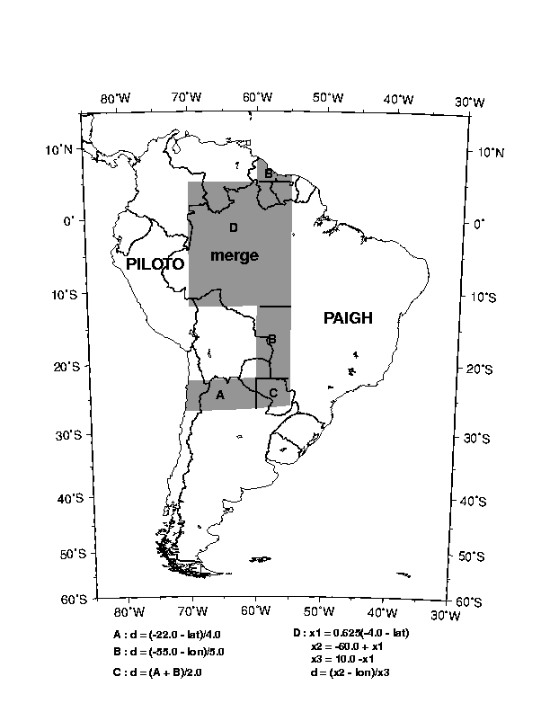
The seismic hazard map of South America depicts the median PGA with a 10% probability of exceedance in 50 years (fig. 6). The 0.5° by 0.5° PAIGH and PILOTO grids of values were interpolated and resampled to a 0.1° by 0.1° grid using GMT software (Wessel and Smith, 1995). The grids were combined as follows (fig. 7):
- PAIGH values were unaltered for southern and eastern South America
- PILOTO values were smoothed into PAIGH values in the merge region
PGA = da + (1-d)b
where a = the PAIGH PGA value, b = the PILOTO PGA value, and d = 0 along the west boundary of the merge zone and d = 1 along the east and south boundary of the merge zone. The linear operator d varied with latitude, longitude, or both, and was recalculated in 0.1 ° steps in each direction (fig. 7).
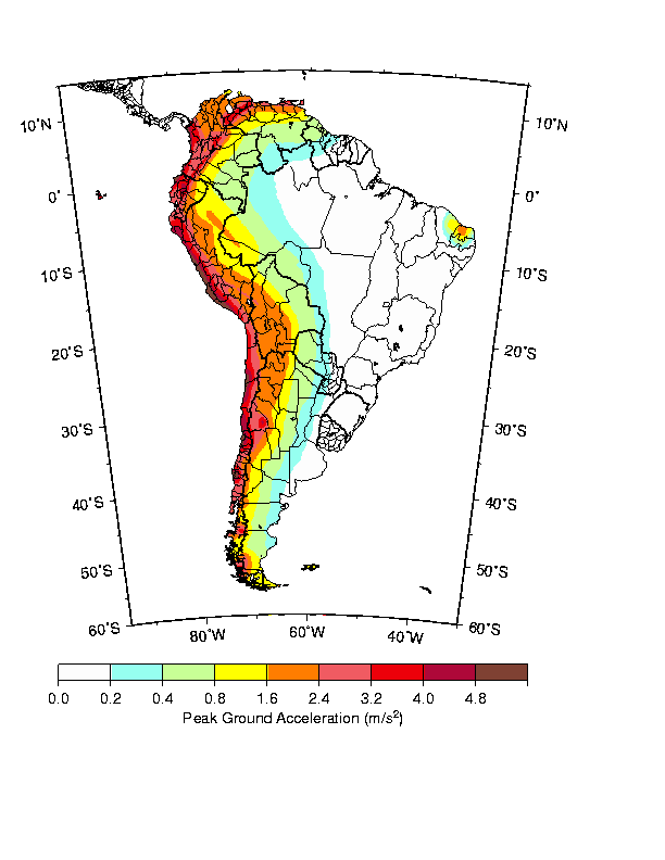
The highest seismic hazard values are along the west coast of South America, coincident with the subduction of the Cocos and Nazca plates beneath the Caribbean and South American plates. The highest hazard values are due to the possibility of the repeat of the 1960 Chilean earthquake. High hazard values are due to the possibilities of repeats of any of the large (M > 8) damaging earthquakes anywhere along the west coast of South America.
Improvements in future maps will involve inclusion
of scenario events for South America, updated regionally appropriate ground
motion relationships, increases in the amount and bandwidth of recorded
earthquake data, and the production of several SA maps.
Western Hemisphere
The seismic hazard maps of North and Central America and the Caribbean (Shedlock, 1998) and South America (fig. 6) have been combined to form the seismic hazard map of the western hemisphere (fig. 8). The seismic hazard map of the Americas depicts PGA with a 10% chance of exceedance in 50 years. The site classification is rock everywhere except Canada and the United States, which assume rock/firm soil reference ground conditions. PGA calculated for rock/firm soil sites will be larger than PGA calculated for rock sites for a given earthquake. Thus, the PGA values calculated for Canada and the United States are systematically larger (£ 25% larger) than PGA values calculated for México, Central and South America, and the Caribbean. The return period for Mexico is 500 years. The return period for all other countries is 475 years. This seismic hazard map of the Americas depicts the shaking hazard that will have the largest effect on one to two story structures (the largest class of structures in the Americas).
The areas of greatest hazard are along the subduction plate boundaries of Alaska, Central America, South America, the eastern Caribbean and México, the transform plate boundaries of the northern Caribbean and western U.S., and the southeast coast of Hawaii. Although Hawaii is not near a plate boundary, it is a ?hot-spot?, where whole-plate (rather than intraplate) tectonic processes dominate.
In general, the energy release in large subduction zone earthquakes is much greater than the energy release in transform fault (strike-slip) earthquakes. The 1960 Chile (M 9.5) and the 1964 Alaska (M 9.2) subduction zone earthquakes are the largest earthquakes ever recorded. Nonetheless, the highest hazard value calculated in the Americas is in southern California (U.S.), along the San Andreas fault (even when reduced to match the site classification of other countries). Large subduction zone earthquakes are deep (many tens to hundreds of km) and the subduction zones along the west coast of the Americas are tens to hundreds of km offshore. Thus, energy released in a large subduction zone earthquake has begun to attenuate before it reaches onshore population centers. Earthquakes along the San Andreas fault (and transform faults in general) are shallow (< 20 km) and often involve surface rupture. The San Andreas fault is onshore for much of its length, and passes through southern California. Thus, energy released in a large San Andreas fault earthquake passes through population centers immediately, producing a higher shaking hazard.
Exposure and vulnerability to the effects of earthquakes
is increasing as urban centers grow, especially in tectonically active
areas. The economic and social effects of earthquakes can be reduced through
a comprehensive assessment of seismic hazard and risk that leads to increased
public awareness, seismically sensitive land-use planning, and the implementation
of seismically sound building construction codes. Probabilistic seismic
hazard maps serve as the bases of building design maps in many of the countries
of the Americas. These PGA maps and supporting documentation are designed
to provide a useful global seismic hazard framework and serve as a resource
for any national or regional agency for further detailed studies applicable
to their needs.
Acknowledgements
This seismic hazard maps of South America and the
Americas are the result of decades of work and the contributions of hundreds
of scientists and technical personnel, as well as universities and public
and private agencies and organizations. Although it is impractical name
everyone, we are grateful to every contributor. In particular, we are grateful
to John Adams, Christina Dimatè, Art Frankel, Steven Halchuk, Walter
Montero, John Shepherd, and Ramon Zúñiga. Thanks to P. Wessel
and W.H.F. Smith for developing GMT, which we used to produce figures 1,
3, and 5-8 in this text. The principle authors (and affiliations) of the
authors of the maps combined to produce this map are listed under "Contact
Information" (below). Many more contributors are listed in the "References"
section.
Contributors and Contact Information
This seismic hazard map of the Americas is the result
of decades of work and the contributions of hundreds of scientists and
technical personnel, as well as universities and public and private agencies
and organizations, throughout the Americas. The principal authors (and
affiliations) of the maps combined to produce this map are:
Canada
J. Adams, D.H. Weichert, S. Halchuk, and P. Basham
Geological Survey of Canada
Contact:
John Adams (adams@seismo.nrcan.gc.ca)
Stephen Halchuk (halchuk@seismo.nrcan.gc.ca)
Geological Survey of Canada
1 Observatory Crescent
Ottawa, ON
K1A 0Y3
Canada
Central America and the Caribbean
Walter Montero P., Giovanni Peraldo H., and Wilfredo Rojas Q.
Universidad de Costa Rica
J.G. Tanner1, J.B. Shepherd2, C.M. McQueen2, and L.L. Lynch3
University of Western Ontario1, University of Lancaster2,
and University of the West Indies3
Contact:
Walter Montero P. (wmontero@cariari.ucr.ac.cr)
Escuela Centroamericana de Geologia
Universidad de Costa Rica
Apartado 35-2060
San José, Costa Rica
James G. Tanner (jtanner@execulink.com)
IPGH
R.R. #1
Union, ON
NOL 2L0
Canada
México
R. Zuñiga, G. Suárez, M. Ordaz, and V. García-Acosta
Universidad Nacional Autonoma De Mexico
Contact:
Ramon Zúñiga (ramon@ollin.igeofcu.unam.mx)
Instituto de Geofisica
UNAM
Cd. Universitaria
Coyoacán
México 04510, D.F.
México
South America
Larry A. Drake - Observatorio San Calixto, Bolivia
M. Cristina Dimatè C. - INGEOMINAS, Colombia
Hugo Yepes - Escuela Politecnica Nacional, Ecuador
Leonidas Ocola - Instituto Geofisica del Peru
Herbert Rendon - FUNVISIS, Venezuela
J.G. Tanner - University of Western Ontario
J.B. Shepherd - University of Lancaster
Contact:
M. Christina Dimatè C. (cdimate@ametista.ingeomin.gov.co)
INGEOMINAS
Diagonal 53 N. 34-53
Santsfè de Bogotà
COLOMBIA
James G. Tanner (jtanner@execulink.com)
IPGH
R.R. #1
Union, ON
NOL 2L0
Canada
United States
A. Frankel, R. Wesson, C. Mueller, F. Klein, T. Barnhard, D. Perkins,
E.V. Leyendecker, N. Dickman, S. Harmsen, S. Hanson, and M. Hopper
United States Geological Survey
Contact:
Art Frankel (afrankel@usgs.gov)
USGS
MS 966 Box 25046
Denver, CO 80225
U.S.A.
References
Aki, K. and P.G. Richards (1980): Quantitative Seismology: Theory and Methods, I, W.H. Freeman, San Francisco, 557 pp.
Anderson, J.G (1997): Nonparametric description of peak acceleration above a subduction thrust, Seism. Res. Lett., 68, 86-93.
Boore, D.M., W.B. Joyner and T.E. Fumal (1993): Estimation of response spectra and peak accelerations from western North American earthquakes: An interim report, US Geol. Surv. Open-File Rep. 93-509, 72 p.
Boore, D.M., W.B. Joyner and T.E. Fumal (1994): Estimation of response spectra and peak accelerations from western North American earthquakes: An interim report Part 2, US Geol. Surv. Open-File Rep. 94-127, 40 p.
Borcherdt, R.D. (1993): Simplified site classes and empirical amplification factors for site-dependent code provisions, Proc. Intl. Workshop Strong Motion Data, Part and Harbor Res. Inst., Kanagawa, 2, 399-427.
Campbell, K.W. and Y. Bozorgnia (1994): Near-source attenuation of peak horizontal acceleration from world-wide recorded from 1957 to 1993, Proc. Fifth US Natl. Conf. Earthquake Eng., EERI, 3, 283--292.
Climent, A., W. Taylor, M.C. Real, W. Strauch, G.Santana, M. Villagran, A. Dahle and H. Bungam (1994): Spectral strong motion attenuation in Central America, NORSAR Tech. Rep. 2-17, 46 pp.
Cornell, C.H., 1968, Engineering seismic risk analysis, Bull. Seism. Soc. Am., 58, 1583-1606.
Crouse, C.B. (1991): Ground motion attenuation equations for earthquakes on the Cascadia subduction zone, Earthq. Spect., 7, 201-236.
Dimatè, M.C. and others (1998): PILOTO - Seismic hazard map of the Andean region, this volume.
Giesecke, A. and others (1998): CERESIS - Seismic hazard map of South America, this volume.
Joyner, W.B., and D.M. Boore (1993): Methods of regression analysis of strong motion data, Bull. Seism. Soc. Am., 83, 469-487.
Kanamori, H. (1977): The energy release in great earthquakes, J. Geophys. Res., 82, 2981-2987.
McGuire, R.K. (1993): Computation of seismic hazard, in Giardini, D., and Basham, P.W., (Eds.), "Global Seismic Hazard Assessment Program," Annali di Geofisica, 34, 181-200.
NEHRP (1994): Recommended provisions for the Development of Seismic Regulations for New Buildings, prepared by Building Seismic Safety Council for Federal Emergency Management Agency, Washington, D.C.
Shedlock, K.M. (1998): Seismic hazard map of North and Central America and the Caribbean, this volume.
Shedlock, K.M. and N.A. Abrahamson (1997): Ground motion attenuation in subduction zones, Proc. Earthquakes - Converging at Cascadia, AEG Spec. Pub 10, 79-87.
Singh, S.K., R. Apsel, J. Fried and J.N. Brune (1982): Spectral attenuation of SH-waves along the Imperial Fault, Bull. Seism. Soc. Am., 72, 2003-2016.
Tanner, J.G. and J.B. Shepherd (1997): Seismic hazard in Latin America and the Caribbean, Volume I: Project catalog and seismic hazard maps, IRDC, Ottawa, 143 p.
Veneziano, D., C.A. Cornell and T. O?Hara (1984): Historical method of seismic hazard analysis, Elect. Power Res. Inst. Rep. NP-3438, Palo Alto.
Wessel, P. and W.H. Smith (1995): GMT Version 3 Technical
Reference and Cookbook, NOAA N/OES12, 92 pp.
Figure
1. The major tectonic plates of the Americas are named in white
letters. The "J" denotes the Juan de Fuca and the smaller Explorer (north)
and Gorda (south) plates. The "E" denotes the Easter plate. The "F" denotes
the Juan Fernandez plate. The small Rivera plate abuts the Cocos plate
on the northwest.
Figure
2. Earthquake catalogs (instrumental and historical), geodetic
monitoring, and GPS measurements provide data on the order of tens to hundreds
of years. Paleoseismology, geology, and regional tectonic studies extend
the temporal range of information into the thousands, and possibly tens
of thousands of years. These different types of data also provide spatial
resolution of deformation at different scales. For example, GPS data provide
spatial resolution of deformation on the order of cm, while historic seismicity
data provide resolution of deformation on the order of tens to hundreds
of km. Seismographs and strong motion instruments (instrumental seismicity)
record deformation on the order of mm and cm, although the information
gleaned from instrumental seismicity (locations) can provide deformation
information over distances of km to hundreds of km. (Figure provided by
E. Schweig)
Figure
3. Seismicity and seismic zones for South America determined by
the Pilot Project for Regional Earthquake Monitoring and Seismic Hazard
Assessment (PILOTO). (Left) South America seismicity, 1471 - 1994. M
? 5.0. Sizes of the dots are scaled to magnitude. Colors of the dots denote
depths: red = 0 - 30 km, pink = 30 - 70 km, green = 70 - 110 km, light
blue = 110 - 150 km, and blue ? 150 km. (Right) Seismic zones used to calculate
the hazard values for South America. The blue zones are ?background? zones,
where the seismicity is not well defined. The green zones are ?seismogenic?
zones, where the seismicity is well defined, and often associated with
distinct tectonic structures. The heavy black lines are subduction zones,
modeled as faults for hazard calculations. (Figure modified from Dimatè
et al., this volume.)
Figure 4. An example of a suite of attenuation relationships. Peak ground acceleration (PGA), in units of g, predicted by six attenuation relationships for an M 8.1 earthquake in the Cascadia (western North America) region. (t/r) means the values are predicted for a thrust or reverse earthquake. + signifies that there are co-authors of the functions. (A2) refers to the model designation given by Anderson (1997). (ra40) means that the values are calculated assuming an intraslab earthquake at 40 km hypocentral depth. (mod) signifies that the values are calculated from the modified version of the Crouse (1991) relationships.
(Figure is taken from Shedlock and Abrahamson, 1997.)
Figure
5. The locations of damaging earthquakes used to determine the
seismic hazard in South America. Earthquakes with M ³
4.6 that occurred during the years 1900 through 1994 are plotted. Symbol
sizes correspond to M.
Figure
6. The seismic hazard map of South America. PGA with a 10% chance
of exceedance in 50 years is depicted in m/s2.
Figure
7. The PGA maps calculated by PAIGH and PILOTO were combined into
a single PGA map of South America. The values calculated by each group
are the mapped values in the marked, unshaded regions. The shaded merge
zone has boundaries at 26°
S, 22° S, 12°
S, 5° N, 70°
W, 60° W, and
55° W.
Figure
8. The seismic hazard map of the Americas depicting peak ground
acceleration (PGA), given in units of m/s2,
with a 10% chance of exceedance in 50 years. The site classification is
rock everywhere except Canada and the United States, which assume "rock/firm
soil" reference ground conditions. The return period for Mexico is 500
years. The return period for all other countries is 474.56 years.