IGCP Seismotectonics and Seismic Hazard Assessment
n.382 of the Mediterranean Basin (SESAME)
ANNUAL REPORT 1999
Summary
Goal of the IGCP n.382 project Seismotectonics and Seismic Hazard Assessment of the Mediterranean Basin (SESAME, 1996-2000) is to produce a uniform seismotectonic zonation and seismic hazard assessment for the Mediterranean region. The project aims to increase the use of geological evidence in seismic hazard assessment by adopting a uniform probabilistic seismotectonic approach to compute seismic hazard throughout the Mediterranean and by incorporating geological evidence to supplement the historical record of seismicity in building a statistical model of seismogenic sources. The SESAME strategy is based on the integration and coordination of national, multi-national and regional programs operating in the Mediterranean.
Programs and test-areas for multi-national seismic hazard assessment have been active in different areas of the Mediterranean area: Ibero-Maghreb, central-northern Europe, Pannonian Basin, Adriatic Sea, Middle-East, Caucasus, Greece and Turkey. In coordination with the Global Seismic Hazard Assessment Program (ILP, ICSU, UN/IDNDR) and with the European Seismological Commission, SESAME has set up a schedule for the standardization of data bases, assessment methodology and hazard maps, and for the integration of the regional results into a homogeneous source zones and hazard mapping for the whole Mediterranean basin. The GSHAP (1992-1998) is now finished and the volume of regional reports and the global map have now been published (list of publications enclosed), while SESAME and the Working Group on Seismic Hazard of the European Seismological Commission (ESC/WG-SHA) will continue until the year 2000 for the Mediterranean area. The work is conducted in three phases:
The present report summarizes the progress and cooperation in regional seismic hazard assessment, the achievements and specific activities/meetings of SESAME in 1999, the plans for the final year 2000, the 1999 budget and the main publications.
Progress in regional SHA in the Mediterranean
SHA in the Mediterranean area is coordinated under a number of regional, multi-national and national initiatives. Here we first describe the progress in the different areas, then summarize the work done toward achieving a basic level of unification in the whole Mediterranean. All details on activities in previous years are found in the SESAME report 1996-97 and 1998.
CENTRAL-NORTHERN EUROPE
Minor changes have been made with respect to the GSHAP implementation in Central-Northern Europe, coordinated by the GFZ Regional Centre in Potsdam and including the territory north of 46°N. The seismic hazard for France has now been completed also south of 46°N and a second hazard zonation is now available for Poland, Czech Republic and Slovakia, coordinated by Prague University. (Grünthal et al., 1999a).
IBERO-MAGHREB
This project, coordinated by CSIC in Barcelona, includes Spain, Portugal, Morocco, Algeria and Tunisia. The catalogue, homogeneous zoning and SHA map were completed in 1997-98. (Jimenez et al., 1999).
ADRIA
This project includes all countries bordering on the Adriatic Sea (Italy, Switzerland, Austria, Slovenia, Croazia, Albania, Greece) coordinated by OGS of Trieste. A final iteration on the source zone model and the seismic hazard was conducted in Pisa (2/98; sponsored by SESAME), and the final model hazard results presented at the 1998 ESC assembly (Tel Aviv, 8/98). (Slejko et al., 1999).
EASTERN MEDITERRANEAN
The IGCP-SESAME and the UNESCO/USGS RELEMR are coordinating their activities toward a unified hazard mapping for the whole area (Turkey, Syria, Lebanon, Cyprus, Israel, Jordan, Egypt, Palestine, Saudi Arabia and Arabian Peninsula). Several planning and review meetings have been held so far in the area. In 1996 and 1997 SESAME organized two Training workshops on seismotectonics and seismic hazard analysis in the Eastern Mediterranean countries (Cairo, 12/96, 12/97). RELEMR organized workshops and special sessions dedicated also to hazard assessment in Cyprus (12/96), Thessalonicki (8/97) and Cyprus (10/97). Following this last meeting, joint SESAME/RELEMR activities were conducted in 1998 with the aim of producing a preliminary regional map of SHA, starting from existing regional PGA maps, and to verify the feasibility of a common strategy for future regional zoning. During the winter 1998, all existing hazard maps for the area were transferred to ETH Zurich, digitized and joined into a common geographic gridding. This first product was then critically analyzed by all contributing countries in Amman (5/98; sponsored by SESAME), with the aim to homogeneize the maps and smooth border discontinuities. After a second mapping iteration, the final preliminary map for the Near East was presented and discussed in Tel Aviv (8/98; sponsored by SESAME). A third workshop was organized by RELEMR in Istanbul (10/98), where a new strategy to build a commont earthquake catalogue, source zones and common hazard has been established for the whole region. In 1999, regional integration in hazard assessment was the main goal of meetings in Tehran (5/99) and Cyprus (10/99). (Grünthal et al., 1999b).
CAUCAS
The project includes the Caucasian Republics (Armenia, Ukraine, Georgia, Turmenistan, Azerbaijan), Russia, Iran and Turkey. The coordinated catalogue, homogeneous zoning and SHA map were completed in 1997. (Balassanian et al., 1999).
NORTHERN EURASIA
The JIPE of Moscow is coordinating the seismic hazard mapping for the whole FSU territory. This five-year program, initiated before the FSU break-up and interrupted during the period of more intense political turmoil, has been restarted, leading to the compilation of the seismic catalogue and the SHA, using for the first time a probabilistic approach. Technical workshops are held routinely in Moscow. The whole area has been subdivided in five blocks, and the final catalogue, the model of source zones and lineaments and the hazard maps were released in early 1998. (Ulomov et al., 1999).
CIRCUM-PANNONIAN
The EU-QSEZ-CIPAR project includes the countries of the Circum-Pannonian basin: Hungary, Romania, Slovania, Croatia, Albania in addition to Italy and UK. While the aim of this independent project was to produce a deterministic hazard assessment for the region, a specific source zoning (1997) and probabilistic hazard assessment (1998) were produced by BGS, Edinbourgh, for comparison with the deterministic results and for inclusion in SESAME and GSHAP. (Musson, 1999).
GREECE
The official national hazard map of Greece has been contributed to the SESAME Mediterranean map (see below), while a new schedule to produce a national source zone model (not yet existing) and a new hazard map adjusted in critical border areas has been now established for 1999 by the groups in Thessalonicki and Athens.
TURKEY
The Kandilli Observatory of Istanbul has represented Turkey in the activities of the Caucasus and Eastern Mediterranean projects. Following the evaluation of the preliminary Mediterranean map (see below), a revised zoning and hazard maps are being produced to correct discrepancies in the Aegean and Eastern Anatolia border areas. (Erdik et al., 1999).
SESAME hazard map
During 1997-98 the GFZ of Potsdam lead the efforts to collect and fit together the SHA maps derived in the individual regional projects described above. The preliminary PGA map includes the contributions of Ibero-Maghreb, Adria, Central-Northern Europe, Northern Eurasia, Caucasus, Greece, Turkey and Circum Pannonian and is accompanied by a compilation of the individual source zones. The draft maps were presented and discussed at the 1998 ESC assembly (Tel Aviv, 8/98) during the SESAME special events. The Near-East map was presented separately. In 1999 the first joint maps were produced (see figures) and published (Gruenthal et al., 1999b). The production of the unifiend source zone models is the key goal for 2000 (see below).
SESAME events 1999
Two technical workshops were organized in the Eastern Mediterranean, within the regional framework described above. One was supported by SESAME.
In addition, SESAME sponsored a working meeting of the coordinators of the different regional test areas in occasion of the IUGG General Assembly in Birmingham (7/99) and the traveling expenses for scientists from the Mediterranean basin (i.e. Libya) to work on the unification of the regional SHA map conducted at SED/ETHZ.
SESAME planned activities 1998-2000
Following the strategy decided in TelAviv (8/97), SESAME and the ESC/WG-SHA are proceeding with the following 5 steps program:
A 1-year contract, supported by SED/ETHZ, has been allocated to M.J. Jimenez of CSIC, Barcelona, to complete the work, in cooperation with other European and Mediterranean centers. The planned schedule calls for the first model to be presented At the EGS 2000 Assembly (Nice, April 27, 2000), to be finalized in a technical workshop in Slovenja (Poljce, May 22-24, 2000). The final source models and hazard results will be presented at the ESC 2000 General Assembly (Lisbon, September 13, 2000).
Publications
The regional reports are now published in the GSHAP volume, printed in late 1999 by Annali di Geofisica and now in distribution. All reports, databases, catalogues, procedures, maps and results are now loaded on the web site http://www.seismo.ethz.ch/GSHAP. The global map was released with a press conference at AGU (Dec. 1999) and reviewed very favourably by ABC, CNN, EOS, Discovery. The map has been printed in 11000 copies by USGS and a second print will be done in March, due to high demand. The Annali volume was printed in 3000 copies.
Budget 1999
The SESAME budget for 1999 was of 6,250$. It was used as seed money to support the workshops in Tehran (2,000$) and Birmingham (1,500$), and the travel expenses connected with the compilation of the regional map of seismic source zones (2’000$). Expenses have been anticipated directly from the SED, Zurich.
Budget 2000
The plan for the final SESAME year 2000 (see above) is to use the IGCP contribution to support the participation of scientists from the Mediterranean basin in the activities planned for the preparation of the final seismic sources model and the regional hazard assessment maps. Regional workshops are scheduled in Nice (EGS, 27/4/2000; 1’500$), Slovenja (Seismicity modeling in seismic hazard mapping, May 22-24, 2000; 2’000$), and Lisbon (ESC, September 13, 2000; 2’000$).
The SESAME request for the final year 2000 is of 5’500$.
Report prepared on February 3, 1999, by Domenico Giardini & S. Sellami, SED/ETHZ
List of Publications
S. Balassanian, T. Ashirov, T. Chelidze, A. Gassanov, N. Kondorskaya, G. Molchan, B. Pustovitenko, V. Trifonov, V. Ulomov, D. Giardini, M. Erdik, M. Ghafory-Ashtiany, G. Grünthal, D. Mayer-Rosa, V. Schenk & M. Stucchi, Seismic hazard assessment for the Caucasus test area, Annali Geofis., 42, 1139-1151, 1999
M. Erdik, Y. Biro, T. Onur, K. Sesetyan & G. Birgoren, Assessment of earthquake hazard in Turkey and neighboring regions, Annali Geofis., 42, 1125-11138, 1999
D. Giardini, editor, The Global Seismic Hazard Assessment Program 1992-1999, Special Issue, Annali Geofis., 42, 248 pp, 1999
D. Giardini, The Global Seismic Hazard Assessment Program (GSHAP): 1992-1999, Annali Geofis., 42, 957-974, 1999
G. Grünthal, C. Bosse, T. Camelbeeck, T. de Crook, J.-C. Gariel, S. Gregersen, B. Guterch, P. Halldorsson, P. Labak, C. Lindholm, W. Lenhardt, P. Mäntyniemi, D. Mayer-Rosa, R. Musson, V. Schenk, Z. Schenkova, D. Slejko, R. Verbeiren, R. Wahlström, B. Zabukovec & T. Ziros, Seismic hazard assessmet for Central, North and Northwest Europe: GSHAP Region 3, Annali Geofis., 42, 999-1012, 1999a
G. Grünthal, C. Bosse, S. Sellami, D. Mayer-Rosa and D. Giardini, Compilation of the GSHAP regional seismic hazard for Europe, Africa and the Middle East, Annali Geofis., 42, 1215-1223, 1999b
D. Giardini, G. Grünthal, K. Shedlock and P. Zhang, The GSHAP global seismic hazard map, Annali Geofis., 42, 1225-1230, 1999
M.J. Jimenez, M. Garcia-Fernandez, M. Chadi, D. El Foul, A. Izquierdo, J.-M. Martinez-Solares, C. Sousa-Oliveira & B.-A. Tadili, Seismic hazard assessment in the Ibero-Maghreb Region. . Annali Geofis., 42, 1057-1066, 1999
R. Musson, 1999. Probabilistic seismic hazard maps for the North Balkan region. Annali Geofis., 42, 1109-1124, 1999
D. Slejko, Camassi, R., Cecic, I., Herak, D., Herak, M., Kociu, S., Kouskouna, V., Lapajne, J., Makropoulos, K., Meletti, C., Muco, B., Papaioannou, C., Peruzza, L., Rebez, A., Scandone, P., Sulstarova, E., Voulgaris, N., Zivcic, M., and Zupancic, P., 1999. GSHAP seismic hazard assessment for the Adria region, Annali Geofis., 42, 1085-1108, 1999
B. Tavakoli, & Ghafory-Ashtiany, M., 1998. Seismic hazard assessment of Iran, Annali Geofis., 42, 1013-1022, 1999
V. Ulomov, L. Shumilina, V. Trifonov, T. Kronrod, k. Levi, N. Zhalkovsky, V. Imaev, A. Ivatschenko, V. Smirnov, A. Gusev, S. Balassanian, A. Gassanov, R. Ayzberg, T. Chelidze, A. Kurskeev, A. Tudukulov, A. Drumya, S. Negmatullaev, T. Ashirov, B. Pustovitenko & K. Abdullabekov, 1999. Seismic hazard of northern Eurasia, Annali Geofis., 42, 1023-1038, 1999
.
Figure Captions
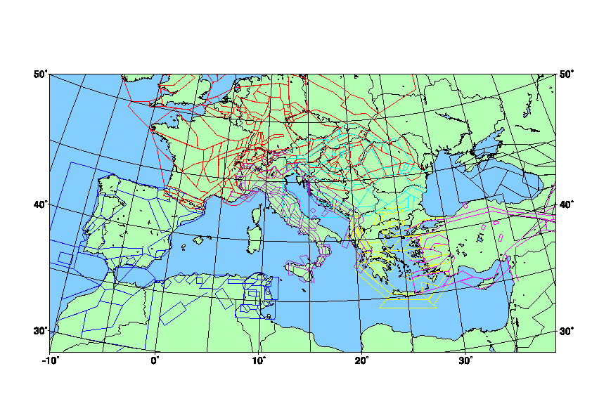
Figure 1. Compilation of all the seismic sources produced for the test areas in the larger Mediterranean area.
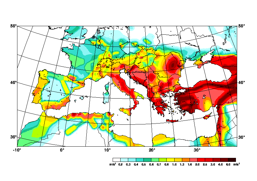
Figure 2. Horizontal peak ground acceleration seismic hazard map representing stiff site conditions for an exceedance or occurrence rate of 10% within 50 years for the Mediterranean region.