María-José Jiménez(1), Mariano García-Fernández(1)
and the GSHAP Ibero-Maghreb Working Group(2)
Abstract
The contribution of the Ibero-Maghreb region to the global
GSHAP map has been the result of a fruitful cooperation among the participants
in the established Working Group including representatives from Algeria,
Morocco, Portugal, Spain and Tunisia and coordinated by ICTJA-CSIC, Spain.
For the first time, a map of regional seismic source zones is presented,
and the agreement on a common procedure for hazard computation in the region
has been achieved. The computed Ibero-Maghreb seismic hazard map constitutes
the first step towards a uniform hazard assessment for the region. Further
joint regional efforts are still needed for earthquake hazard studies based
on a homogeneous regional earthquake catalogue. Ongoing initiatives in
relation to seismic hazard assessment in the Mediterranean should profit
both from these results and the established cooperation among different
groups in the region as well as contribute to future regional studies.
The seismic hazard mapping for the Ibero-Maghreb region did not follow
strictly the GSHAP implementation guidelines (Basham and Giardini, 1993)
due to time limitations. The coordination of the activities in this region
by the Institute of Earth Sciences "Jaume Almera" / C.S.I.C. (ICTJA/CSIC)
in Barcelona, Spain, started only in December 1996, and a special time
schedule was established in order to attain the expected results on time
for the contribution to the global GSHAP map.
At a first Planning Meeting in Barcelona, Spain, on December 18, 1996,
a plan of activities was launched to produce a preliminary seismic hazard
map of the region (30N-44N, 12W-12E) to be presented in occasion of the
1997 IASPEI General Assembly in Thessaloniki, Greece. During the Planning
Meeting national representatives from each country in the region accepted
to be responsible for providing the necessary input data (Algeria: Djamal
El Foul; Morocco: Ben-Aissa Tadili; Portugal: Carlos Sousa-Oliveira; Spain:
Mariano García-Fernández; and Tunisia: M?hamed Chadi).
In order to simplify the hazard assessment procedure, and due to the
limited time, all national representatives agreed on leaving to the ICTJA/CSIC
team the responsibility for performing all mapping computations and on
providing the necessary pre-processed input data. It was decided to use
the computer code SEISRISK III (Bender and Perkins, 1987) to generate a
preliminary map of peak ground acceleration (PGA) in g-units for a 90%
probability of non-exceedance in 50 years, considering a single regional
attenuation law. The production of such regional hazard map was performed
in two steps: First, individual hazard maps for each country were obtained
based on the input data provided by the national representatives, and compared
with available national maps to check the influence of both, the computation
algorithm and the applied data reduction. Second, after technical discussions
with the national representatives, a single set of regional non-overlapping
source zones was defined, based on the available individual zoning map
of each country, for which new activity parameters were calculated wherever
needed.
Input data requested to the national representatives were received by
April 1997 and a preliminary hazard map for each country was produced by
the ICTJA/CSIC team. The input data from Spain was provided by the Spanish
Instituto
Geográfico Nacional (IGN). To discuss these preliminary results,
and to solve problems related to the definition of seismic source zones
across national borders, a second Technical Workshop was held in Barcelona
on May 11-14, 1997. A representative of the Spanish IGN (A. Izquierdo)
attended this meeting. Based on the outcome of this second workshop a first
version of the seismic hazard map for the whole region was produced on
July 1997.
2.1 Seismicity
The basic seismicity data from each country consisted on a national
earthquake catalogue spaning different time periods and also with different
earthquake size descriptor among them. Due to the above mentioned limitation
in time, no work was performed in order to obtain an homogeneous regional
catalogue. Based on the available national catalogues a List of Significant
Earthquakes (LSE) in the region was generated by merging the information
of the five countries, avoiding spatial overlapping, as detailed in Table
I, and with a uniform earthquake size value on moment magnitude, M, obtained
through the empirical relationships given by Johnston (1996a, b). The LSE
(Appendix A) contains the seismicity from 1900 to 1989 with estimated moment
magnitude M³ 4.5. The LSE is thus just
a general description of the seismicity in the region and not a regional
earthquake catalogue.
2.2 Source Zones
The definition of seismic source zones in the region is highly heterogeneous,
ranging from very detailed small sized sources (Tunisia), and even fault
sources (Algeria), to very wide zones (Morocco, Portugal). In most of the
cases seismicity is the main criterion parameter based on which source
boundaries are defined, although some raw tectonic information had also
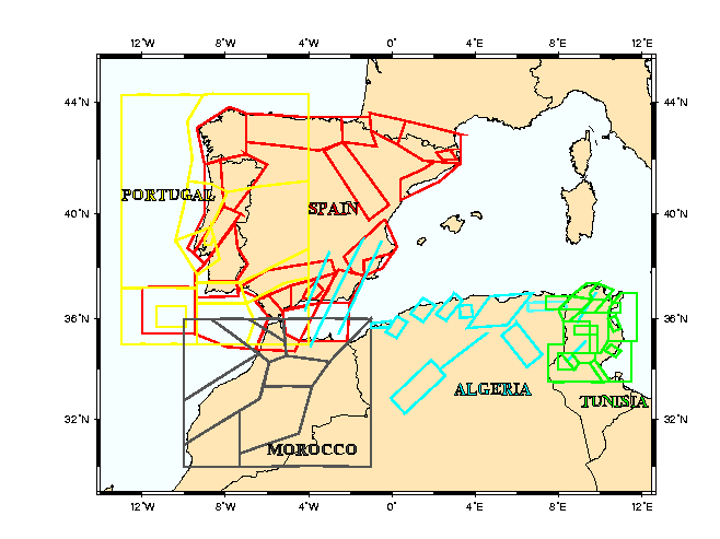
been included. Figure 1 shows the original source zones from each individual
country.
The time limitations did not allow redefining regional source zones
for the whole area, and only those sources overlapping at national borders
were considered candidates to be redefined, although trying to keep as
much information as possible from original sources, to avoid performing
too many new calculations for which no time was available. New sources
were defined based on the existing ones after technical discussions among
the national representatives. Reshaping was carried out according to known
main seismotectonic features and avoiding overlapping or duplicate zones.
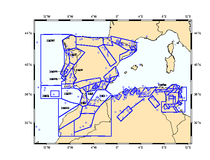
Figure 2, in which redefined sources are labeled, includes the final distribution
of the Ibero-Maghreb regional seismic source zones together with the epicenters
contained in the enclosed LSE. The geographical coordinates of the final
source zones can be found in Appendix B.
2.3 Seismicity Parameters
The seismicity parameters of the source zones from each country were
provided in different format. Either the a and b values of the Gutenberg-Richter
relationship (Morocco, Tunisia), or the b-value and the annual rate for
a minimum earthquake size (Portugal, Spain), or the number of events by
magnitude intervals (Algeria) were given. The seismicity parameters for
the reshaped sources (those labeled in Figure 2) were obtained by keeping
the original source b-value from which originated, and further calculating
earthquake occurrences according to the new reshaped area. A general recalculation
was performed for all sources in order to obtain values in terms of moment
magnitude, M, through the appropriated empirical relation from Johnston
(1996a, b). In Appendix C the main activity parameters (i.e., earthquakes/year
km2, b-value, and maximum magnitude) of the Ibero-Maghreb regional
source zones are summarized.
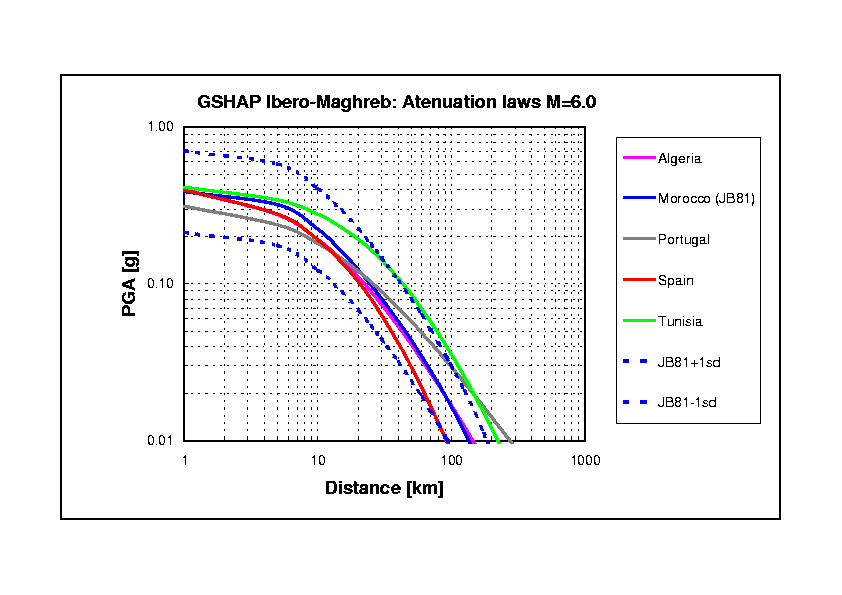
2.4 Attenuation laws
While in some countries only one attenuation law was used to obtain
the available national maps (Algeria, Morocco, Tunisia), others considered
several regional laws to apply to different sources (Portugal, Spain).
A special case corresponds to the Atlantic offshore sources west of the
Iberian Peninsula for which both, Portugal and Spain, assume a very specific
low attenuation relation for the strong earthquakes taking place there
(i.e., Lisbon 1755).
Some differences existed as well in the parameters based on which the
individual attenuation laws were given. Some included PGA in terms of magnitude,
M, and distance, R, (Algeria, Morocco, Tunisia), while in other cases the
ground motion parameter considered was intensity, I, either in terms of
magnitude and distance (Portugal), or epicentral intensity, I0,
and distance (Spain). For these last cases, it was agreed to obtain PGA
in g-units through the empirical relationship log PGA = 0.30 I - 3.22,
included in the Spanish Building Code NCS-94 (IGN, 1995). Table II includes
all the attenuation relationships used in the region. In the case of Portugal
and Spain, only the general one for land sources is included. These same
laws are plotted in Figure 3 for a magnitude M=6.0 earthquake.
For the calculations in the final map, in order to keep a minimum of
homogeneity, only one attenuation law was considered. Since a regional
law based on good and enough acceleration data was lacking, the relationship
proposed by Joyner and Boore (1981) was chosen. This relationship could
roughly represent an average of the different laws used in the region,
as it can be observed in Figure 3. The hazard calculations were performed
considering one standard deviation in log PGA.
3. Seismic hazard computation and results
As a first step, and based on the input data provided by the national
representatives, preliminary seismic hazard maps of each country in the
region were produced by the ICTJA-CSIC team using SEISRISK III. The maps
were compared with existing national maps when available, and if not, obtained
results were discussed with the national representatives in order to achieve
a general agreement on its validity. The observed differences should arise
either from the computation algorithm or from those simplified procedures
that had to be applied in some particular cases (e.g., using only one attenuation
law for Spain).
The final seismic hazard map of the Ibero-Maghreb region in terms of
PGA, in m/s2, with a 90% probability of non-exceedance in 50
years is shown in Figure 4, with color-coded contouring.
The highest expected hazard corresponds to El Asnam region in Algeria
(3.5 ms-2 or 0.36g). Values between 2.5-3.0 ms-2
are found in Alger region, Algeria, and in Tunis-Bizerte and Chardimaou-Bou
Salem regions, in Tunisia. Sour El Ghozlane and Mostaganem regions, in
Algeria, and Granada and Alicante-Murcia regions, in Spain show values
between 2.0-2.5 ms-2.
Although having followed a simplified procedure, this regional Ibero-Maghreb
hazard map is representative as a relative hazard map, i.e., PGA values
should be considered as indicative of regional relative seismic hazard.
The obtained results as a whole are in good agreement with recently published
regional studies (e.g., Benouar et al., 1996).
4. Concluding remarks
This computed Ibero-Maghreb seismic hazard map constitutes only a first
step for a uniform hazard assessment for the region. Nevertheless, the
effort in compiling all the information regarding presently used methodologies
for seismic hazard practice in the region, together with available catalogues,
source zoning and attenuation laws, results in invaluable information towards
the GSHAP objectives of regionalized approach of hazard assessment for
the Western Mediterranean.
Despite the original lack of homogeneity on the basic elements for seismic
hazard assessment, fruitful cooperation among the representatives of each
country allowed to produce this first version of a regional seismic hazard
map. For the first time, a map of regional seismic source zones is presented,
and the agreement on a common procedure for hazard computation in the region
has been achieved.
Further joint regional efforts are still needed for seismic hazard assessment
studies in the Ibero-Maghreb region based on a homogeneous regional earthquake
catalogue. Ongoing initiatives in the Mediterranean like the CEPRIS Council
of Europe OPA-center, the UNESCO IGCP-project SESAME, the UNESCO/USGS-project
RELMER, and the ESC Working Group on Seismic Hazard might profit both from
these results and from the established close cooperation attained in the
framework of GSHAP; as well as contribute to future regional studies.
Acknowledgments
The two technical workshops held in Barcelona, Spain, were partially
funded by UNESCO (contract SC/RP205.550.6) and the SESAME project (UNESCO/IGCP-382).
References
Basham, P.W. And D. Giardini (1993): Technical guidelines for global
seismic hazard assessment, in GSHAP Technical Planning Volume, edited
by D. Giardini and P.W. Basham, Ann. Geofis., 36, 15-24.
Bender, B. and D.M. Perkins (1987). SEISRISK III: A Computer program
for Seismic Hazard Estimation, U.S. Geological Survey Bulletin,
1772,
48 pp.
Benouar, D., G.L. Molas and F. Yamaziki (1996). Earthquake hazard mapping
in the Maghreb countries, Earthq. Eng. & Struct. Dyn., 25,
1151-1164.
IGN (1995). Norma de Construcción Sismorresistente (Parte
General y Edificación) NCSE-94, Centro Nacional de Información
Geográfica, Madrid, Spain, 105 pp. (in Spanish).
Johnston, A.C. (1996a). Seismic moment assessment of earthquakes in
stable continental regions-I. Instrumental seismicity, Geophys. J. Int.,
124,
381-414.
Johnston, A.C. (1996b). Seismic moment assessment of earthquakes in
stable continental regions-II. Historical seismicity, Geophys. J. Int.,
125,
639-678.
Joyner, W.B. and D.M. Boore (1981). Peak horizontal acceleration and
velocity from strong-motion records including records from the 1979 Imperial
Valley, California earthquake, Bull. Seism. Soc. Am., 71,
2011-2038.
Table captions
Table I. Earthquake catalogue available
from each country in the Ibero-Maghreb region. ML: Local Richter
magnitude (different definition in each country; e.g., in Tunisia it is
obtained from MCS intensity). IMSK: MSK intensity. LSE: List
of Significant Earthquakes (see text).
Table II. Attenuation relationships used
in the Ibero-Maghreb region.
Figure captions
Figure 1. Original earthquake source
zones from each individual country in the Ibero-Maghreb region.
Figure 2. Final distribution of earthquake
source zones for the Ibero-Maghreb region, and epicenters of the generated
List of Significant Earthquakes with M³
4.5 from 1900 to 1989.
Figure 3. Selected attenuation relationships
from each country in the Ibero-Maghreb region.
Figure 4. Earthquake hazard map of
the Ibero-Maghreb region. PGA [m/s2] with 90% probability of
non-exceedance in 50 years.
|
|
||||
|
|
|
|
|
|
|
|
|
|
|
|
|
|
|
|
|
|
|
|
|
|
|
|
|
|
|
|
|
37° N-44° N; 1.5° W-5° E |
|
|
|
|
|
|
|
|
|
|
|
|
|
|
|
|
|
|
|
|
|
|
|
|
ANNEX 1: National Representatives And Contributing Organizations
Mohammed CHADI
Institute National de la Meteorologie
BP 156, TN-2035, Tunis-Carthage, TUNISIA
Phone: +216-1-773400 ; Fax: +216-1-772609
Djamal EL FOUL
CGS
Rue Kaddour Rahim pro., BP 252, 16040 Hussein-Dey, Algiers, ALGERIA
Phone: +213-2-599091 ; Fax: +213-2-776656
Mariano GARCÍA-FERNÁNDEZ
Inst. De Ciencias de la Tierra ?Jaume Almera? - CSIC
Lluís Solé i Sabaris, s/n, E-08028 Barcelona, SPAIN
Phone: +34-93-4095410 ; Fax: +34-93-4110012 ; E-mail: mgarcia@ija.csic.es
Arantxa IZQUIERDO and José-Manuel MARTÍNEZ-SOLARES
Instituto Geográfico Nacional. Área de Geofísica.
General Ibáñez de Ïbero, 3, E-28003 Madrid, SPAIN
Phone: +34-91-5333800 ; Fax: +34-91-5979616
Carlos SOUSA-OLIVEIRA
Inst. Superior Técnico, Dept. Engenharia Civil
Avda. Rovisco Pais, 1, P-1096, Lisboa, PORTUGAL
Phone: +351-1-8418201 ; Fax: +351-1-8497650 ; E-mail: csoliv@civil1.ist.utl.pt
Ben-Aissa TADILI
Université Mohammed V / Institut Scientifique
Charia Ibn Batouta, B.P. 703, Agdal-Rabat, MOROCCO
Phone: +212-7-774543 ; Fax: +212-7-774540
List of Significant Earthquakes in the Ibero-Maghreb region from 1900 to 1989 with estimated moment magnitude M³ 4.5.
(file: ibmaappA.xls)
Geographical coordinates of earthquake source zones in the Ibero-Maghreb region.
(file: ibmaappB-xls)
Seismicity parameters of the earthquake source zones in the Ibero-Maghreb region.
(file: ibmaappC.xls)
PGA values [m/s2] with 90% probability of non-excedance in 50 years
in the Ibero-Maghreb region.
(file: ibmaappD.xls)